
File:Geofeatures-PacificNW.png
No higher resolution available.
Geofeatures-PacificNW.png (357 × 450 pixels, file size: 180 KB, MIME type: image/png)
| This is a file from the Wikimedia Commons. Information from its description page there is shown below. Commons is a freely licensed media file repository. You can help. |
Summary
| Description |
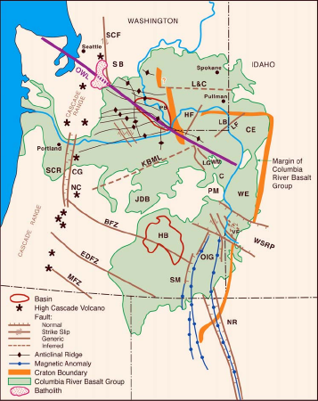
Map Showing the Extent of the Columbia River Basalt Group and Main Structural Features. OWL = Olympic-Wallowa lineament LB = Lewiston basin WW = Walla Walla C = Cornucopia part of the Chief Joseph dike swarm WSRP = western Snake River Plain OIG = Oregon-Idaho graben SM = Steens Mountains NR = Nevada Rift zone MF BFZ = Brothers Fault zone EDFZ = Eugene-Denio fault zone MFZ = Modoc fault zone WE = Weiser embayment PM = Pedro Mountains KBLM = Klamath-Blue Mountains linear (gravity) JDB = John Day basin LG = LaGrange graben HF = Hite fault LF = Limekiln fault NC = Newberry caldera CG = Cascade graben L&C = Lewis and Clark line (gravity anomaly) SCF = Straight Creek fault SB = Snoqualmie batholith SCR = Southern Cascade Range HB = Harney Basin |
| Source |
Extracted from "Goldschmidt Conference 2005: Field Trip Guide", U. S. Dept. of Energy, Pacific Northwest National Laboratory report 15221. [1] |
| Author | B. S. Martin, H. L. Petcovic, S. P. Reide |
Licensing
| This image is a work of a United States Department of Energy (or predecessor organization) employee, taken or made as part of that person's official duties. As a work of the U.S. federal government, the image is in the public domain.
Please note that national laboratories operate under varying licences and some are not free. Check the site policies of any national lab before crediting it with this tag.
|

|
Original upload log
Transferred from en.wikipedia to Commons using For the Common Good.
The original description page was here. All following user names refer to en.wikipedia.
| Date/Time | Dimensions | User | Comment |
|---|---|---|---|
| 22:21, 17 March 2009 | 357 × 450 (184,571 bytes) | w:en:J. Johnson (talk | contribs) | Extracted from "Goldschmidt Conference 2005: Field Trip Guide", U. S. Dept. of Energy, Pacific Northwest National Laboratory report 15221. [http://www.pnl.gov/main/publications/external/technical_reports/PNNL-15221.pdf] |
File history
Click on a date/time to view the file as it appeared at that time.
| Date/Time | Thumbnail | Dimensions | User | Comment | |
|---|---|---|---|---|---|
| current | 07:58, 26 August 2018 | | 357 × 450 (180 KB) | Vorwald | Transferred from en.wikipedia: see original upload log above |
File usage
The following pages on the English Wikipedia use this file (pages on other projects are not listed):
Global file usage
The following other wikis use this file:
- Usage on de.wikipedia.org
- Usage on www.wikidata.org