
File:Generalplan Ost map.tiff
Size of this JPG preview of this TIF file: 800 × 540 pixels. Other resolutions: 320 × 216 pixels | 640 × 432 pixels | 1,024 × 691 pixels | 1,166 × 787 pixels.
Original file (1,166 × 787 pixels, file size: 2.63 MB, MIME type: image/tiff)
| This is a file from the Wikimedia Commons. Information from its description page there is shown below. Commons is a freely licensed media file repository. You can help. |
Summary
| Description |
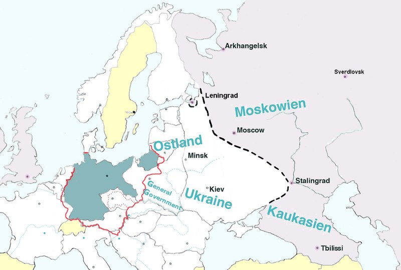
English: Map of Europe, with pre-WW2 borders, showing the extension of Nazi Germany's GENERALPLAN OST worked out 1940-1942.
Legend: Blue-green – Germany (Deutsches Reich). Dotted black line – the extension of detailed plans of a second ”phase of settlement” (Siedlungsphase). Light grey – the greatest extension of Generalplan Ost. The names in blue – Nazi regions called Reichskommissariat : Ostland (1941-1945), Ukraine (1941-1945), Moskowien (never realized), Kaukasien (never realized). Yellow – neutral countries. The map is based on texts and graphics on Deutsche Forschungsgemeinschaft: Der Generalplan Ost der Nationalsozialisten, [1] |
||
| Date | |||
| Source | Own work | ||
| Author | Lihagen | ||
| Permission (Reusing this file) |
|
Licensing
I, the copyright holder of this work, hereby publish it under the following license:
| This file is made available under the Creative Commons CC0 1.0 Universal Public Domain Dedication. | |
| The person who associated a work with this deed has dedicated the work to the public domain by waiving all of their rights to the work worldwide under copyright law, including all related and neighboring rights, to the extent allowed by law. You can copy, modify, distribute and perform the work, even for commercial purposes, all without asking permission.
|
File history
Click on a date/time to view the file as it appeared at that time.
| Date/Time | Thumbnail | Dimensions | User | Comment | |
|---|---|---|---|---|---|
| current | 17:22, 9 February 2017 |  | 1,166 × 787 (2.63 MB) | Claude Zygiel | Leningrad |
| 17:18, 9 February 2017 |  | 1,166 × 787 (2.63 MB) | Claude Zygiel | Sverdlovsk, Tbilissi, borders during the war in green, neutral states in yellow | |
| 17:35, 28 July 2016 |  | 1,166 × 787 (2.63 MB) | Julieta39 | Pre-WW2 borders in grey, Gross-Deutschlands Reich in red, add General-Government | |
| 19:07, 10 April 2011 |  | 1,166 × 787 (2.63 MB) | Lihagen | {{Information |Description ={{en|1=Map of Europe, with pre-WW2 boarders, showing the extension of Nazi Germany's GENERALPLAN OST. Legend: Dark grey – Germany (Deutsches Reich); Dotted black line – the extension of a second ”phase of resattlemen |
File usage
The following pages on the English Wikipedia use this file (pages on other projects are not listed):
Global file usage
The following other wikis use this file:
- Usage on ar.wikipedia.org
- Usage on cs.wikipedia.org
- Usage on da.wikipedia.org
- Usage on el.wikipedia.org
- Usage on es.wikipedia.org
- Usage on et.wikipedia.org
- Usage on fr.wikipedia.org
- Usage on he.wikipedia.org
- Usage on id.wikipedia.org
- Usage on it.wikipedia.org
- Usage on ja.wikipedia.org
- Usage on mk.wikipedia.org
- Usage on nl.wikipedia.org
- Usage on no.wikipedia.org
- Usage on ro.wikipedia.org
- Usage on ru.wikipedia.org
- Usage on sh.wikipedia.org
- Usage on sk.wikipedia.org
- Usage on sr.wikipedia.org
- Usage on sv.wikipedia.org
- Usage on uk.wikipedia.org
- Usage on zh.wikipedia.org