
File:General Roys Baseline.jpg
Size of this preview: 735 × 600 pixels. Other resolutions: 294 × 240 pixels | 588 × 480 pixels | 909 × 742 pixels.
Original file (909 × 742 pixels, file size: 325 KB, MIME type: image/jpeg)
| This is a file from the Wikimedia Commons. Information from its description page there is shown below. Commons is a freely licensed media file repository. You can help. |
Summary
| Description |
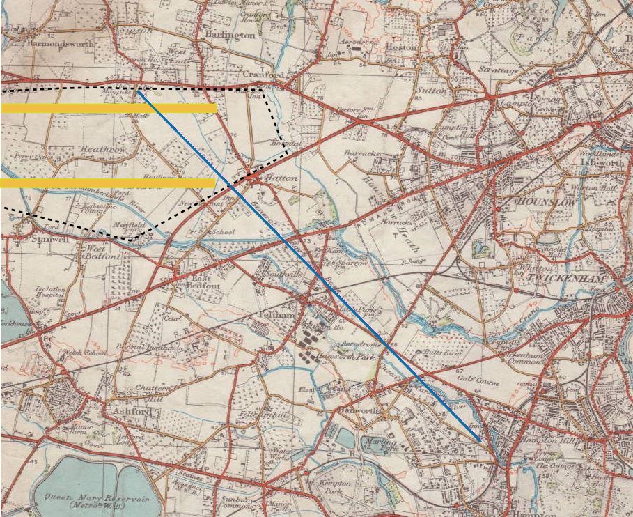
English: General William Roy's survey baseline, from Heathrow to Hampton, west of London, constructed for the Anglo-French Survey before the start of the Ordnance Survey. See File:Heathrow Before World War II Map.jpg for a larger-scale map of the Heathrow area as it was around 1935. |
| Source | from Ordnance Survey map |
| Author | Ordnance Survey |
Licensing
This work is an Ordnance Survey map over 50 years old, which is covered by Crown Copyright which in this case expires 50 years after publication. Ordnance Survey does however ask that they be credited and that the date of publication be given.
Any ancillary rights gained through the creation of the electronic version are granted as freely usable under any circumstances.
|
This work created by the United Kingdom Government is in the public domain.
This is because it is one of the following:
HMSO has declared that the expiry of Crown Copyrights applies worldwide (ref: HMSO Email Reply)
|
 |
Original upload log
The original description page was here. All following user names refer to en.wikipedia.
| Date/Time | Dimensions | User | Comment |
|---|---|---|---|
| 2015-02-05 19:10 | 909×742× (332524 bytes) | Peter Mercator | Added indication of extent of Heathrow airport. |
| 2015-02-04 23:42 | 908×742× (217790 bytes) | Anthony Appleyard | Geberal roy's survey baseline, from Heathrow to Hampton, the start of the [[:en:Ordnance Survey|]]. |
File history
Click on a date/time to view the file as it appeared at that time.
| Date/Time | Thumbnail | Dimensions | User | Comment | |
|---|---|---|---|---|---|
| current | 04:50, 24 February 2017 | | 909 × 742 (325 KB) | OgreBot | (BOT): Reverting to most recent version before archival |
| 04:50, 24 February 2017 |  | 908 × 742 (213 KB) | OgreBot | (BOT): Uploading old version of file from en.wikipedia; originally uploaded on 2015-02-04 23:42:26 by Anthony Appleyard | |
| 01:37, 24 February 2017 |  | 909 × 742 (325 KB) | Innotata | Transferred from en.wikipedia |
File usage
The following pages on the English Wikipedia use this file (pages on other projects are not listed):
Global file usage
The following other wikis use this file:
- Usage on fr.wikipedia.org