
File:Galvestonmap1900hurricane.png

Size of this preview: 800 × 452 pixels. Other resolutions: 320 × 181 pixels | 640 × 362 pixels | 1,024 × 579 pixels | 1,280 × 724 pixels | 2,560 × 1,448 pixels | 6,067 × 3,431 pixels.
Original file (6,067 × 3,431 pixels, file size: 13.85 MB, MIME type: image/png)
| This is a file from the Wikimedia Commons. Information from its description page there is shown below. Commons is a freely licensed media file repository. You can help. |
Summary
| Description |
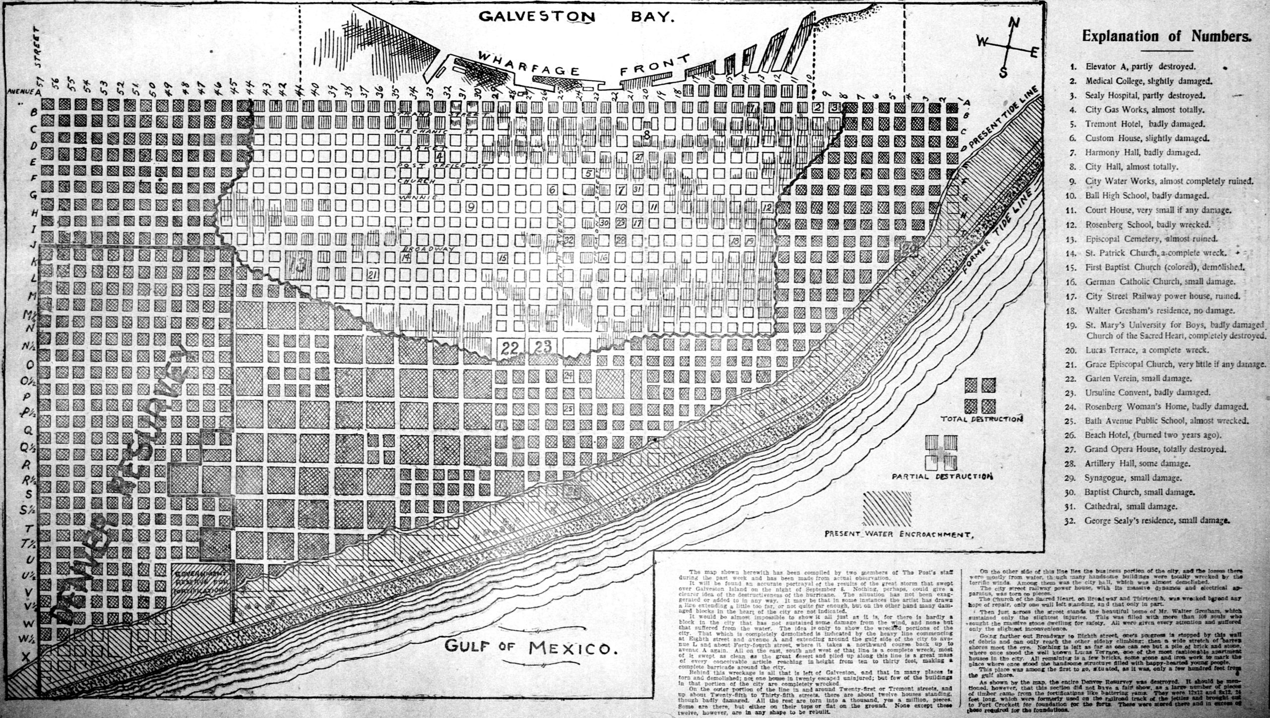
English: A map of Galveston illustrating the destruction of the 1900 hurricane. Originally published in The Houston Post on September 27, 1900 |
| Date | |
| Source | https://www.newspapers.com/clip/26052143/the_houston_post/ |
| Author | The Houston Post staff |
Licensing
This work is in the public domain in the United States because it was published (or registered with the U.S. Copyright Office) before January 1, 1929.
Public domain works must be out of copyright in both the United States and in the source country of the work in order to be hosted on the Commons. If the work is not a U.S. work, the file must have an additional copyright tag indicating the copyright status in the source country.
Note: This tag should not be used for sound recordings. |
File history
Click on a date/time to view the file as it appeared at that time.
| Date/Time | Thumbnail | Dimensions | User | Comment | |
|---|---|---|---|---|---|
| current | 21:14, 1 May 2023 | | 6,067 × 3,431 (13.85 MB) | Spheroidite | higher resolution from source |
| 20:42, 22 December 2018 |  | 1,068 × 592 (785 KB) | 12george1 | User created page with UploadWizard |
File usage
The following pages on the English Wikipedia use this file (pages on other projects are not listed):
Global file usage
The following other wikis use this file:
- Usage on it.wikipedia.org
- Usage on pt.wikipedia.org