
File:Galapagos Islands topographic map-fr.png

Size of this preview: 600 × 600 pixels. Other resolutions: 240 × 240 pixels | 480 × 480 pixels | 768 × 768 pixels | 1,024 × 1,024 pixels | 2,160 × 2,160 pixels.
Original file (2,160 × 2,160 pixels, file size: 2.14 MB, MIME type: image/png)
| This is a file from the Wikimedia Commons. Information from its description page there is shown below. Commons is a freely licensed media file repository. You can help. |
Summary
| Camera location | | View this and other nearby images on: OpenStreetMap |
|---|
| Description |
|
||
| Date | |||
| Source |
Own work
|
||
| Author | Eric Gaba (Sting - fr:Sting) | ||
| Permission (Reusing this file) |
|
||
| Other versions |
[]
|

.png)


Licensing
I, the copyright holder of this work, hereby publish it under the following licenses:

|
Permission is granted to copy, distribute and/or modify this document under the terms of the GNU Free Documentation License, Version 1.2 or any later version published by the Free Software Foundation; with no Invariant Sections, no Front-Cover Texts, and no Back-Cover Texts. A copy of the license is included in the section entitled GNU Free Documentation License. |
This file is licensed under the Creative Commons Attribution-Share Alike 4.0 International, 3.0 Unported, 2.5 Generic, 2.0 Generic and 1.0 Generic license.
- You are free:
- to share – to copy, distribute and transmit the work
- to remix – to adapt the work
- Under the following conditions:
- attribution – You must give appropriate credit, provide a link to the license, and indicate if changes were made. You may do so in any reasonable manner, but not in any way that suggests the licensor endorses you or your use.
- share alike – If you remix, transform, or build upon the material, you must distribute your contributions under the same or compatible license as the original.
You may select the license of your choice.
File history
Click on a date/time to view the file as it appeared at that time.
| Date/Time | Thumbnail | Dimensions | User | Comment | |
|---|---|---|---|---|---|
| current | 00:34, 20 July 2010 | | 2,160 × 2,160 (2.14 MB) | Sting | Reverted to version as of 14:35, 19 July 2010 : test ended |
| 00:28, 20 July 2010 |  | 2,160 × 2,160 (4.3 MB) | Sting | sRGB converted (just for test) | |
| 14:35, 19 July 2010 |  | 2,160 × 2,160 (2.14 MB) | Sting | Color profile | |
| 14:37, 17 November 2009 |  | 2,160 × 2,160 (2.14 MB) | Sting | Embedded sRGB profile | |
| 12:52, 3 November 2008 |  | 2,160 × 2,160 (2.06 MB) | Sting | Corrections | |
| 01:35, 5 July 2008 |  | 2,160 × 2,160 (2.06 MB) | Sting | Oups ! | |
| 01:19, 5 July 2008 |  | 2,160 × 2,160 (2.07 MB) | Sting | Several little improvements | |
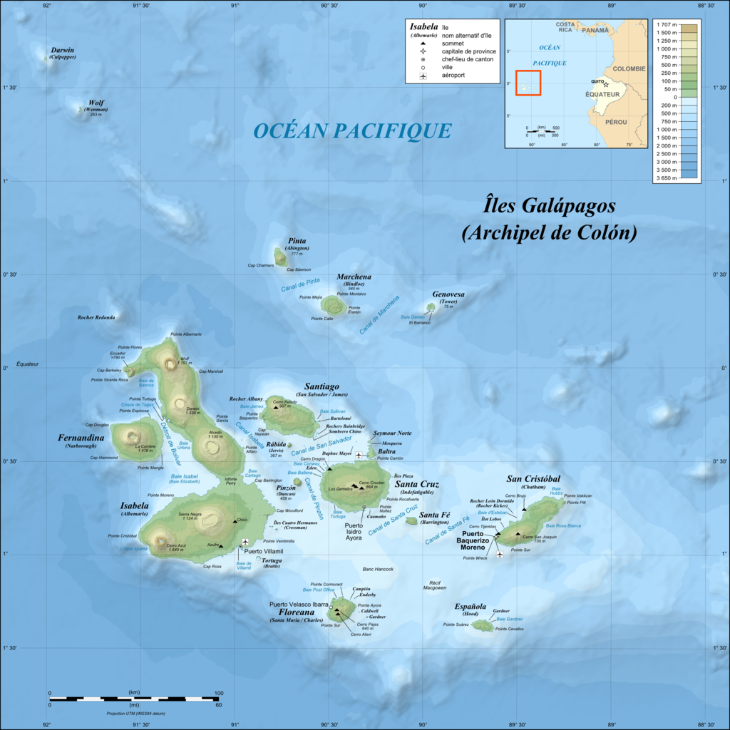
| 02:17, 3 July 2008 |  | 2,160 × 2,160 (1.87 MB) | Sting | == Summary == {{Location|00|30|00|S|90|30|00|W|scale:1000000}} <br/>{{Information |Description={{en|Topographic and bathymetric map of the Galápagos Islands, Ecuador.}} {{fr|Carte topographique et bathymétrique |
File usage
The following pages on the English Wikipedia use this file (pages on other projects are not listed):
Global file usage
The following other wikis use this file:
- Usage on fr.wikipedia.org
- Usage on fr.wiktionary.org
- Usage on hu.wikipedia.org