
File:GSPC map.png
No higher resolution available.
GSPC_map.png (350 × 350 pixels, file size: 15 KB, MIME type: image/png)
| This is a file from the Wikimedia Commons. Information from its description page there is shown below. Commons is a freely licensed media file repository. You can help. |
Summary
| Description |
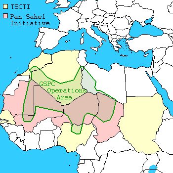
English: Al-Qaeda Organization in the Islamic Maghreb area of operations |
||||
| Date | 24 July 2010 (original upload date) | ||||
| Source | http://en.wikipedia.org/wiki/Image:GSPC_map.png | ||||
| Author | Alinor at en.wikipedia | ||||
| Other versions |
|


.svg)

.png)


.svg)


.svg)


_Territory_Change_2014-2016.gif)

_(within_Northern_Syria).svg)


.png)
.svg)


_map.png)
.svg)


.svg)


Licensing
Orthuberra from EN, the copyright holder of this work, hereby publishes it under the following license:

|
Permission is granted to copy, distribute and/or modify this document under the terms of the GNU Free Documentation License, Version 1.2 or any later version published by the Free Software Foundation; with no Invariant Sections, no Front-Cover Texts, and no Back-Cover Texts. A copy of the license is included in the section entitled GNU Free Documentation License. |
| This file is licensed under the Creative Commons Attribution-Share Alike 3.0 Unported license. | ||
| Attribution: Orthuberra | ||
| ||
| This licensing tag was added to this file as part of the GFDL licensing update. |

|
This map image could be re-created using vector graphics as an SVG file. This has several advantages; see Commons:Media for cleanup for more information. If an SVG form of this image is available, please upload it and afterwards replace this template with
{{vector version available|new image name}}.
It is recommended to name the SVG file “GSPC map.svg”—then the template Vector version available (or Vva) does not need the new image name parameter. |
File history
Click on a date/time to view the file as it appeared at that time.
| Date/Time | Thumbnail | Dimensions | User | Comment | |
|---|---|---|---|---|---|
| current | 10:56, 20 October 2023 | | 350 × 350 (15 KB) | Hohum | shaded area |
| 10:47, 20 October 2023 |  | 350 × 350 (11 KB) | Hohum | Cartographic colours | |
| 13:48, 29 February 2008 |  | 350 × 350 (10 KB) | Lizrael | {{GFDL-user-w|EN|English Eikipedia|Orthuberra}} http://en.wikipedia.org/wiki/Image:GSPC_map.png |
File usage
The following pages on the English Wikipedia use this file (pages on other projects are not listed):
Global file usage
The following other wikis use this file:
- Usage on ar.wikipedia.org
- Usage on bn.wikipedia.org
- Usage on cs.wikipedia.org
- Usage on cs.wikinews.org
- Usage on da.wikipedia.org
- Usage on de.wikipedia.org
- Usage on he.wikipedia.org
- Usage on id.wikipedia.org
- Usage on it.wikipedia.org
- Usage on ja.wikipedia.org
- Usage on ko.wikipedia.org
- Usage on pl.wikipedia.org
- Usage on pt.wikipedia.org
- Usage on ro.wikipedia.org
- Usage on ru.wikipedia.org
- Usage on ru.wikinews.org
- Usage on simple.wikipedia.org
- Usage on vi.wikipedia.org