
File:GREATER BA RAIL NETWORK-b.png
Size of this preview: 419 × 599 pixels. Other resolutions: 168 × 240 pixels | 336 × 480 pixels | 537 × 768 pixels | 717 × 1,024 pixels | 2,160 × 3,086 pixels.
Original file (2,160 × 3,086 pixels, file size: 1.95 MB, MIME type: image/png)
| This is a file from the Wikimedia Commons. Information from its description page there is shown below. Commons is a freely licensed media file repository. You can help. |
Summary
| Description |
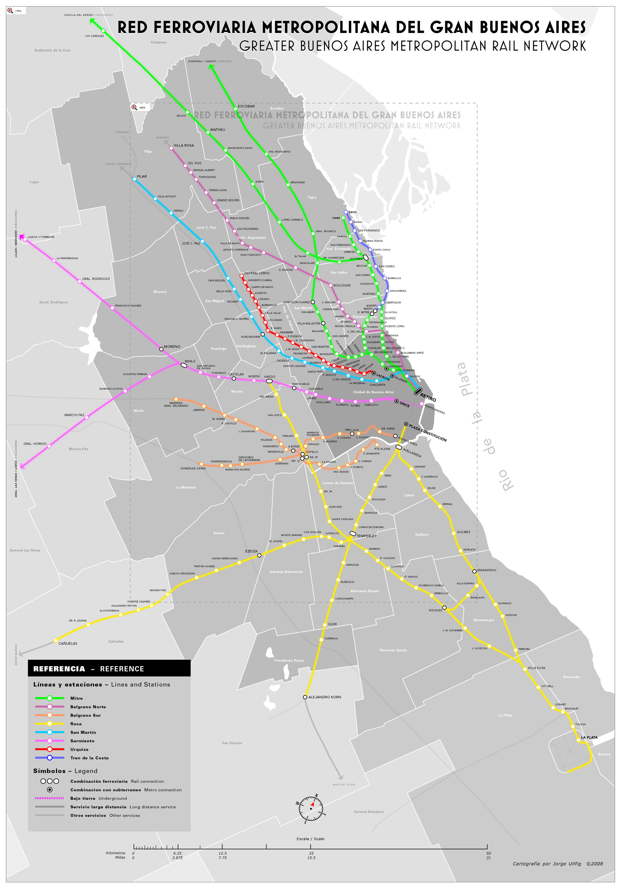
Español: Mapa de la red ferrovial de Buenos Aires
English: Map of the Buenos Aires railway system |
| Date | |
| Source |
Original text : Es: Mapa realizado en Adobe Illustrator y Photoshop en base a datos de dominio publico de Internet y vários atlas geográficos. En: self-made map created in illustrator and photoshop from public domain data information obtained from several internet sources and printed Atlases.) |
| Author | Moebiusuibeom-en (talk) |
Licensing
Moebiusuibeom-en at English Wikipedia, the copyright holder of this work, hereby publishes it under the following licenses:
This file is licensed under the Creative Commons Attribution-Share Alike 3.0 Unported license.
Attribution: Moebiusuibeom-en at English Wikipedia
- You are free:
- to share – to copy, distribute and transmit the work
- to remix – to adapt the work
- Under the following conditions:
- attribution – You must give appropriate credit, provide a link to the license, and indicate if changes were made. You may do so in any reasonable manner, but not in any way that suggests the licensor endorses you or your use.
- share alike – If you remix, transform, or build upon the material, you must distribute your contributions under the same or compatible license as the original.

|
Permission is granted to copy, distribute and/or modify this document under the terms of the GNU Free Documentation License, Version 1.2 or any later version published by the Free Software Foundation; with no Invariant Sections, no Front-Cover Texts, and no Back-Cover Texts. A copy of the license is included in the section entitled GNU Free Documentation License. |
You may select the license of your choice.
Original upload log
Transferred from en.wikipedia to Commons by Magnus Manske using CommonsHelper.
The original description page was here. All following user names refer to en.wikipedia.
- 2008-07-08 17:45 Moebiusuibeom-en 2160×3086× (2046761 bytes) {{Information |Description= '''Es: '''Mapa de la red ferrovial de Buenos Aires '''En: '''Map of the Buenos Aires railway system |Source= '''Es:''' Mapa realizado en Adobe Illustrator y Photoshop en base a datos de dominio publico de Internet y vá
File history
Click on a date/time to view the file as it appeared at that time.
| Date/Time | Thumbnail | Dimensions | User | Comment | |
|---|---|---|---|---|---|
| current | 15:01, 19 February 2011 | | 2,160 × 3,086 (1.95 MB) | File Upload Bot (Magnus Manske) | {{BotMoveToCommons|en.wikipedia|year={{subst:CURRENTYEAR}}|month={{subst:CURRENTMONTHNAME}}|day={{subst:CURRENTDAY}}}} {{Information |Description={{en|'''Es: '''Mapa de la red ferrovial de Buenos Aires '''En: '''Map of the Buenos Aires railway system}} | |
File usage
The following pages on the English Wikipedia use this file (pages on other projects are not listed):
Global file usage
The following other wikis use this file:
- Usage on de.wikipedia.org
- Usage on es.wikipedia.org
- Usage on fr.wikipedia.org
- Usage on it.wikipedia.org
- Usage on ja.wikipedia.org
- Usage on mt.wikipedia.org
- Usage on ro.wikipedia.org
- Usage on sco.wikipedia.org
- Usage on th.wikipedia.org
- Usage on vi.wikipedia.org
- Usage on www.wikidata.org