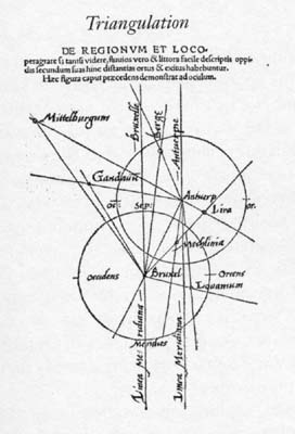
File:G-F triangulation.jpg
G-F_triangulation.jpg (272 × 400 pixels, file size: 21 KB, MIME type: image/jpeg)
File history
Click on a date/time to view the file as it appeared at that time.
| Date/Time | Thumbnail | Dimensions | User | Comment | |
|---|---|---|---|---|---|
| current | 16:46, 30 April 2008 |  | 272 × 400 (21 KB) | Jheald | {{Information |Description=en:Gemma Frisius's 1533 diagram introducing the idea of en:triangulation into the science of surveying. Having established a baseline, eg the cities of Brussels and Antwerp, the location of other cities, eg Middelberg |
File usage
The following pages on the English Wikipedia use this file (pages on other projects are not listed):
Global file usage
The following other wikis use this file:
- Usage on de.wikipedia.org
- Usage on de.wiktionary.org
- Usage on eo.wikipedia.org
- Usage on ja.wikipedia.org
- Usage on pl.wikipedia.org
- Usage on pl.wiktionary.org
- Usage on ru.wikipedia.org
- Usage on sl.wikipedia.org
- Usage on zh.wikipedia.org

