
File:G-ARPI-path.png

Size of this preview: 760 × 600 pixels. Other resolutions: 304 × 240 pixels | 608 × 480 pixels | 973 × 768 pixels | 1,280 × 1,010 pixels | 1,882 × 1,485 pixels.
Original file (1,882 × 1,485 pixels, file size: 2.3 MB, MIME type: image/png)
| This is a file from the Wikimedia Commons. Information from its description page there is shown below. Commons is a freely licensed media file repository. You can help. |
Summary
| Description |
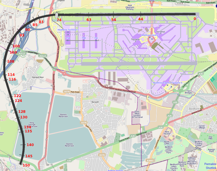
English: Path of final flight of BEA flight 548, operated by aircraft G-ARPI in 1972. The red numbers are times in seconds after brake release. Note that the background map is of Heathrow and its surroundings as they were in 2010, rather than at the time of the flight. |
| Date | (UTC) |
| Source | Based on OpenStreetsMap and AIB report |
| Author | © OpenStreetMap contributors and Crum375 (talk) 05:15, 19 August 2010 (UTC) (using above sources) |
Licensing
This file is licensed under the Creative Commons Attribution-Share Alike 2.0 Generic license.
- You are free:
- to share – to copy, distribute and transmit the work
- to remix – to adapt the work
- Under the following conditions:
- attribution – You must give appropriate credit, provide a link to the license, and indicate if changes were made. You may do so in any reasonable manner, but not in any way that suggests the licensor endorses you or your use.
- share alike – If you remix, transform, or build upon the material, you must distribute your contributions under the same or compatible license as the original.
| Description |
This map was created from OpenStreetMap project data, collected by the community. This map may be incomplete, and may contain errors. Don't rely solely on it for navigation. |
|||
| Date | (see file history) | |||
| Source | openstreetmap.org | |||
| Creator |
OpenStreetMap contributors |
|||
| Permission (Reusing this file) |
OpenStreetMap data is available under the Open Database License (details). Map tiles are licensed under the Creative Commons Attribution-ShareAlike 2.0 license (CC-BY-SA 2.0).
This file is licensed under the Creative Commons Attribution-Share Alike 2.0 Generic license.
|
|||
| Georeferencing | If inappropriate please set warp_status = skip to hide. |
Original upload log
The original description page was here. All following user names refer to en.wikipedia.
| Date/Time | Dimensions | User | Comment |
|---|---|---|---|
| 2010-08-19 05:15 | 1882×1485× (2410188 bytes) | Crum375 | {{Information |Description = Path of final flight of BEA flight 548 G-ARPI |Source = Based on [http://www.openstreetmap.org/ OpenStreetsMap] and [http://www.aaib.gov.uk/cms_resources.cfm?file=/4-1973%20G-ARPI%20Append.pdf AIB report] |Date |
File history
Click on a date/time to view the file as it appeared at that time.
| Date/Time | Thumbnail | Dimensions | User | Comment | |
|---|---|---|---|---|---|
| current | 09:25, 19 June 2015 | | 1,882 × 1,485 (2.3 MB) | Chris j wood | Transferred from en.wikipedia |
File usage
The following pages on the English Wikipedia use this file (pages on other projects are not listed):
Global file usage
The following other wikis use this file:
- Usage on fr.wikipedia.org
- Usage on it.wikipedia.org
- Usage on ja.wikipedia.org
- Usage on ru.wikipedia.org