
File:Fuday.jpg
No higher resolution available.
Fuday.jpg (640 × 480 pixels, file size: 73 KB, MIME type: image/jpeg)
| This is a file from the Wikimedia Commons. Information from its description page there is shown below. Commons is a freely licensed media file repository. You can help. |
| Camera location | | View this and other nearby images on: OpenStreetMap |
|---|
| Object location | | View this and other nearby images on: OpenStreetMap |
|---|
Summary
| Description |
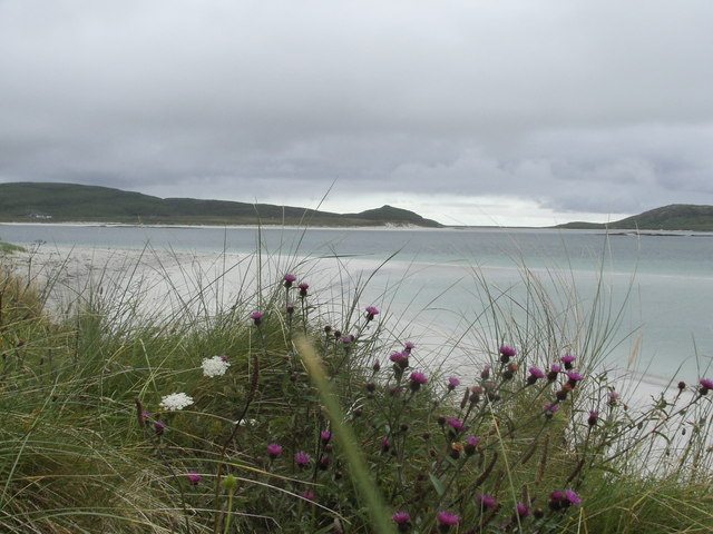
An Caolas Fuideach Fuday (or Fuideagh, pronounced "Fujay") lies off the Eoligarry peninsula at the northern end of Barra, Outer Hebrides. The mile wide sound separating Fuday from Eoligarry is shallow and dotted with reefs and skerries. Cattle used to be swum across the sound for summer grazing. Beyond the flowering w:machair lies the beach Traigh na Reill and across the sound the hills of Eoligarry. It is nearly low water and some of the skerries are visible. |
||
| Date | |||
| Source |
This file is licensed under the Creative Commons Attribution-Share Alike 2.0 Generic license. Attribution: John Hughes
|
||
| Author | John Hughes | ||
| Attribution (required by the license) | John Hughes / An Caolas Fuideach / | ||

_region:GB-GBN_heading:270.00&language=en)
Licensing
This file is licensed under the Creative Commons Attribution-Share Alike 2.0 Generic license.
- You are free:
- to share – to copy, distribute and transmit the work
- to remix – to adapt the work
- Under the following conditions:
- attribution – You must give appropriate credit, provide a link to the license, and indicate if changes were made. You may do so in any reasonable manner, but not in any way that suggests the licensor endorses you or your use.
- share alike – If you remix, transform, or build upon the material, you must distribute your contributions under the same or compatible license as the original.
File history
Click on a date/time to view the file as it appeared at that time.
| Date/Time | Thumbnail | Dimensions | User | Comment | |
|---|---|---|---|---|---|
| current | 17:15, 6 January 2008 | | 640 × 480 (73 KB) | MacRusgail | == Summary == {{Information |Description=An Caolas Fuideach Fuday (or Fuideagh, pronounced "Fujay") lies off the Eoligarry peninsula at the northern end of Barra, Outer Hebrides. The mile wide sound separating Fuday from Eoligarry is shallow and dotted wi |
File usage
The following pages on the English Wikipedia use this file (pages on other projects are not listed):
Global file usage
The following other wikis use this file: