
File:Friar's Cliff, cliffs - geograph.org.uk - 1210129.jpg
No higher resolution available.
Friar's_Cliff,_cliffs_-_geograph.org.uk_-_1210129.jpg (640 × 480 pixels, file size: 73 KB, MIME type: image/jpeg)
| This is a file from the Wikimedia Commons. Information from its description page there is shown below. Commons is a freely licensed media file repository. You can help. |
Summary
| Description |
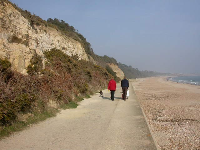
English: Friar's Cliff, cliffs Most of the cliffs between Friar's Cliff & Highcliffe have been invaded by scrub, or planted with trees to combat erosion. 250m remain, of Eocene Boscombe Sands & Barton Clay. Miner bees are much in evidence, flying in & out of holes in the sands in the cliffs. For a full description of local geology, see http://www.soton.ac.uk/~imw/barton.htm |
| Date | |
| Source | From geograph.org.uk |
| Author | Mike Faherty |
| Attribution (required by the license) | Mike Faherty / Friar's Cliff, cliffs / |
| Camera location | | View this and other nearby images on: OpenStreetMap |
|---|
_heading:67.00&language=en)
| Object location | | View this and other nearby images on: OpenStreetMap |
|---|
_heading:67.00&language=en)
Licensing

|
This image was taken from the Geograph project collection. See this photograph's page on the Geograph website for the photographer's contact details. The copyright on this image is owned by Mike Faherty and is licensed for reuse under the Creative Commons Attribution-ShareAlike 2.0 license.
|
This file is licensed under the Creative Commons Attribution-Share Alike 2.0 Generic license.
Attribution: Mike Faherty
- You are free:
- to share – to copy, distribute and transmit the work
- to remix – to adapt the work
- Under the following conditions:
- attribution – You must give appropriate credit, provide a link to the license, and indicate if changes were made. You may do so in any reasonable manner, but not in any way that suggests the licensor endorses you or your use.
- share alike – If you remix, transform, or build upon the material, you must distribute your contributions under the same or compatible license as the original.
File history
Click on a date/time to view the file as it appeared at that time.
| Date/Time | Thumbnail | Dimensions | User | Comment | |
|---|---|---|---|---|---|
| current | 06:41, 26 February 2011 | | 640 × 480 (73 KB) | GeographBot | == {{int:filedesc}} == {{Information |description={{en|1=Friar's Cliff, cliffs Most of the cliffs between Friar's Cliff & Highcliffe have been invaded by scrub, or planted with trees to combat erosion. 250m remain, of Eocene Boscombe Sands & Barton Clay. |
File usage
The following pages on the English Wikipedia use this file (pages on other projects are not listed):