
File:Fresnel zone disrupted.png
Size of this preview: 426 × 599 pixels. Other resolutions: 171 × 240 pixels | 512 × 720 pixels.
Original file (512 × 720 pixels, file size: 33 KB, MIME type: image/png)
| This is a file from the Wikimedia Commons. Information from its description page there is shown below. Commons is a freely licensed media file repository. You can help. |
Summary
| Description |
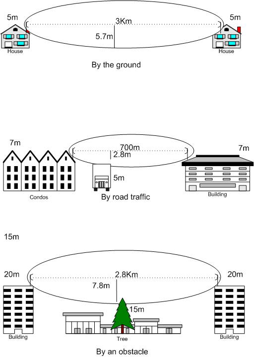
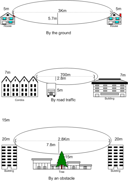
English: This drawing shows how the Fresnel zone can be disrupted by the ground, road traffic and an obstacle like a tree. The drawing was created using visio 2000 SP2 and saved as a .png file. The image was based on this image where there were commercial company names and the licensing status was unknown. Twibright Labs is not a commercial company name. The licensing status is GFDL see http://ronja.twibright.com/drawings/ |
| Date | |
| Source | Own work |
| Author | Kgrr (cc)2007 by Konrad Roeder |
| Other versions | Derivative works of this file: Fresnel zone disruption (compact).PNG |
.PNG)

|
This physics image could be re-created using vector graphics as an SVG file. This has several advantages; see Commons:Media for cleanup for more information. If an SVG form of this image is available, please upload it and afterwards replace this template with
{{vector version available|new image name}}.
It is recommended to name the SVG file “Fresnel zone disrupted.svg”—then the template Vector version available (or Vva) does not need the new image name parameter. |
Licensing
I, Kgrr, the copyright holder of this work, hereby publishes it under the following licenses:

|
Permission is granted to copy, distribute and/or modify this document under the terms of the GNU Free Documentation License, Version 1.2 or any later version published by the Free Software Foundation; with no Invariant Sections, no Front-Cover Texts, and no Back-Cover Texts. A copy of the license is included in the section entitled GNU Free Documentation License. |
| This file is licensed under the Creative Commons Attribution-Share Alike 3.0 Unported license. | ||
| Attribution: I, Kgrr | ||
| ||
| This licensing tag was added to this file as part of the GFDL licensing update. |
This file is licensed under the Creative Commons Attribution 2.5 Generic license.
Attribution: I, Kgrr
- You are free:
- to share – to copy, distribute and transmit the work
- to remix – to adapt the work
- Under the following conditions:
- attribution – You must give appropriate credit, provide a link to the license, and indicate if changes were made. You may do so in any reasonable manner, but not in any way that suggests the licensor endorses you or your use.
You may select the license of your choice.
File history
Click on a date/time to view the file as it appeared at that time.
| Date/Time | Thumbnail | Dimensions | User | Comment | |
|---|---|---|---|---|---|
| current | 15:38, 9 June 2007 | | 512 × 720 (33 KB) | Kgrr | {{Information |Description=This drawing shows how the Fresnel zone can be disrupted by the ground, road traffic and an obstacle like a tree. The drawing was created using visio 2000 SP2 and saved as a .png file |Source=self-made |Date=2007-06-09 |Author= |
File usage
The following pages on the English Wikipedia use this file (pages on other projects are not listed):
Global file usage
The following other wikis use this file:
- Usage on fa.wikipedia.org
- Usage on id.wikipedia.org
- Usage on pl.wikipedia.org
- Usage on pt.wikipedia.org
- Usage on uk.wikipedia.org