
File:Frenchman's Creek, National Historic Site of Canada, Between Fort Erie and Niagara Falls, Ontario (29358757283).jpg

Size of this preview: 800 × 600 pixels. Other resolutions: 320 × 240 pixels | 640 × 480 pixels | 1,024 × 768 pixels | 1,280 × 960 pixels | 2,560 × 1,920 pixels | 4,000 × 3,000 pixels.
Original file (4,000 × 3,000 pixels, file size: 6.18 MB, MIME type: image/jpeg)
| This is a file from the Wikimedia Commons. Information from its description page there is shown below. Commons is a freely licensed media file repository. You can help. |
.jpg)
Summary
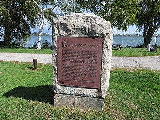
| Description | In an effort to regain the initiative lost at Queenston, the Americans planned a general invasion for 28 November 1812. Before dawn advance parties crossed the Niagara River to cut communications between Fort Erie and Chippawa and to silence the British shore guns. The attackers failed to destroy the bridge over Frenchmen’s Creek and the batteries they had overrun were soon retaken by British reinforcements. After confused fighting the advance parties returned to the American shore. The main assault failed to materialize. The fiasco ended American hopes for victory on the Niagara Frontier in 1812. Historic Sites and Monuments Board of Canada, Government of Canada 1923. |
| Date | |
| Source | Frenchman's Creek, National Historic Site of Canada, Between Fort Erie and Niagara Falls, Ontario |
| Author | Ken Lund from Reno, Nevada, USA |
| Camera location | | View this and other nearby images on: OpenStreetMap |
|---|
.jpg¶ms=042.942388_N_-078.926437_E_globe:Earth_type:camera_source:Flickr_&language=en)
Licensing
This file is licensed under the Creative Commons Attribution-Share Alike 2.0 Generic license.
- You are free:
- to share – to copy, distribute and transmit the work
- to remix – to adapt the work
- Under the following conditions:
- attribution – You must give appropriate credit, provide a link to the license, and indicate if changes were made. You may do so in any reasonable manner, but not in any way that suggests the licensor endorses you or your use.
- share alike – If you remix, transform, or build upon the material, you must distribute your contributions under the same or compatible license as the original.
| This image was originally posted to Flickr by Ken Lund at https://flickr.com/photos/75683070@N00/29358757283. It was reviewed on 10 March 2022 by FlickreviewR 2 and was confirmed to be licensed under the terms of the cc-by-sa-2.0. |
File history
Click on a date/time to view the file as it appeared at that time.
| Date/Time | Thumbnail | Dimensions | User | Comment | |
|---|---|---|---|---|---|
| current | 19:20, 10 March 2022 | | 4,000 × 3,000 (6.18 MB) | Mindmatrix | Transferred from Flickr via #flickr2commons |
File usage
The following pages on the English Wikipedia use this file (pages on other projects are not listed):
Global file usage
The following other wikis use this file:
- Usage on de.wikipedia.org
- Usage on www.wikidata.org
.jpg)