
File:Franklin battle 1600.png

Size of this preview: 486 × 599 pixels. Other resolutions: 195 × 240 pixels | 389 × 480 pixels | 623 × 768 pixels | 831 × 1,024 pixels | 2,400 × 2,957 pixels.
Original file (2,400 × 2,957 pixels, file size: 6.4 MB, MIME type: image/png)
| This is a file from the Wikimedia Commons. Information from its description page there is shown below. Commons is a freely licensed media file repository. You can help. |
Summary
| Description |
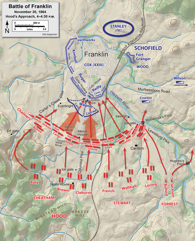
English: Map of the Battle of Franklin of the American Civil War, showing the approach by Hood's Army. Drawn in Adobe Illustrator CC by Hal Jespersen. Graphic source file is available at https://www.cwmaps.com/freemaps.html |
| Date | |
| Source | Own work |
| Author | Hal Jespersen at en.wikipedia |
Licensing
Hal Jespersen at en.wikipedia, the copyright holder of this work, hereby publishes it under the following license:
This file is licensed under the Creative Commons Attribution 3.0 Unported license.
Attribution: Map by Hal Jespersen, www.cwmaps.com
- You are free:
- to share – to copy, distribute and transmit the work
- to remix – to adapt the work
- Under the following conditions:
- attribution – You must give appropriate credit, provide a link to the license, and indicate if changes were made. You may do so in any reasonable manner, but not in any way that suggests the licensor endorses you or your use.
Original upload log
The original description page was here. All following user names refer to en.wikipedia.
- 2010-01-06 23:47 Hlj 2544×3133× (1049178 bytes) Corrected Union positions east of the Columbia Pike. {{cc-by-3.0|Map by Hal Jespersen, www.posix.com/CW}}
- 2010-01-03 00:09 Hlj 2544×3133× (1041498 bytes) {{Information |Description=Map of the [[Battle of Franklin]] of the [[American Civil War]], showing the approach by Hood's Army. Drawn in Adobe Illustrator CS3 by Hal Jespersen. Graphic source file is available at http://www.posix.com/CWmaps/ |Source=own
File history
Click on a date/time to view the file as it appeared at that time.
| Date/Time | Thumbnail | Dimensions | User | Comment | |
|---|---|---|---|---|---|
| current | 19:00, 15 February 2021 | | 2,400 × 2,957 (6.4 MB) | Hlj | improved background accuracy of my previous map |
| 22:07, 29 December 2011 |  | 2,544 × 3,133 (1.49 MB) | Hlj | Corrected minor error of corps names (swapped). Same license. | |
| 17:58, 16 March 2011 |  | 2,544 × 3,133 (1.2 MB) | Hlj | Minor graphical changes to adopt new style of roads and water. Same license. | |
| 15:15, 24 January 2010 |  | 2,544 × 3,133 (1 MB) | BotMultichill | {{BotMoveToCommons|en.wikipedia|year={{subst:CURRENTYEAR}}|month={{subst:CURRENTMONTHNAME}}|day={{subst:CURRENTDAY}}}} {{Information |Description={{en|Map of the en:Battle of Franklin of the en:American Civil War, showing the approach by Hoo |
File usage
The following pages on the English Wikipedia use this file (pages on other projects are not listed):
Global file usage
The following other wikis use this file:
- Usage on de.wikipedia.org
- Usage on es.wikipedia.org
- Usage on fr.wikipedia.org
- Usage on it.wikipedia.org
- Usage on nl.wikipedia.org