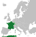
File:France (1945-1949).png

Size of this preview: 713 × 600 pixels. Other resolutions: 285 × 240 pixels | 571 × 480 pixels | 913 × 768 pixels | 1,217 × 1,024 pixels | 1,920 × 1,615 pixels.
Original file (1,920 × 1,615 pixels, file size: 533 KB, MIME type: image/png)
File history
Click on a date/time to view the file as it appeared at that time.
| Date/Time | Thumbnail | Dimensions | User | Comment | |
|---|---|---|---|---|---|
| current | 13:53, 28 January 2024 |  | 1,920 × 1,615 (533 KB) | Pic-Sou | correction of mistake : Algeria was part of France during this period, not a protectorate like Morrocco or Tunisia |
| 10:16, 6 June 2023 |  | 1,920 × 1,615 (526 KB) | SnowieLuna1212 | Bigger file | |
| 02:57, 29 November 2021 |  | 450 × 456 (53 KB) | SenseiAC | Reverted to version as of 19:06, 22 September 2018 (UTC) cohérence avec tout e rete -- ça commence à bien faire... | |
| 15:37, 8 November 2020 |  | 450 × 456 (42 KB) | Houmouvazine | Reverted to version as of 05:29, 11 March 2017 (UTC) - Voir les sources - Merci | |
| 19:06, 22 September 2018 |  | 450 × 456 (53 KB) | SenseiAC | Reverted to version as of 01:01, 4 December 2017 (UTC) All the other maps (1914, 39, 42, 46-57) follow what the legislation was. This map has no reason to be an outlier. | |
| 22:01, 6 December 2017 |  | 450 × 456 (42 KB) | Ms10vc | Reverted to version as of 21:28, 5 November 2017 (UTC) | |
| 01:01, 4 December 2017 |  | 450 × 456 (53 KB) | SenseiAC | Reverted to version as of 14:45, 5 November 2017 (UTC) dura lex, sed lex | |
| 21:28, 5 November 2017 |  | 450 × 456 (42 KB) | Ms10vc | Reverted to version as of 07:18, 21 September 2017 (UTC) La législation coloniale n'est pas une législation et en plus il faut respecter la source | |
| 14:45, 5 November 2017 |  | 450 × 456 (53 KB) | SenseiAC | Reverted to version as of 09:10, 27 August 2017 (UTC) Ce n'est pas une négation des faits, juste le reflets de la législation | |
| 07:18, 21 September 2017 |  | 450 × 456 (42 KB) | Ms10vc | Reverted to version as of 05:29, 11 March 2017 (UTC) == négation du fait colonial |
File usage
The following pages on the English Wikipedia use this file (pages on other projects are not listed):
Global file usage
The following other wikis use this file:
- Usage on ar.wikipedia.org
- Usage on ast.wikipedia.org
- Usage on az.wikipedia.org
- Usage on ca.wikipedia.org
- Usage on cs.wikipedia.org
- Usage on da.wikipedia.org
- Usage on el.wikipedia.org
- Usage on eo.wikipedia.org
- Usage on es.wikipedia.org
- Usage on fa.wikipedia.org
- Usage on fi.wikipedia.org
- Usage on fr.wikipedia.org
- Usage on he.wikipedia.org
- Usage on hr.wikipedia.org
- Usage on it.wikipedia.org
- Usage on ja.wikipedia.org
- Usage on ka.wikipedia.org
- Usage on ko.wikipedia.org
- Usage on lv.wikipedia.org
- Usage on mk.wikipedia.org
- Usage on ms.wikipedia.org
- Usage on nl.wikipedia.org
- Usage on no.wikipedia.org
- Usage on pl.wikipedia.org
- Usage on pt.wikipedia.org
- Usage on ru.wikipedia.org
- Usage on sh.wikipedia.org
- Usage on simple.wikipedia.org
- Usage on th.wikipedia.org
- Usage on tr.wikipedia.org
- Usage on uk.wikipedia.org
- Usage on vi.wikipedia.org
- Usage on www.wikidata.org
- Usage on zh.wikipedia.org

