
File:Fort De Lassomption Memphis TN LoC map.jpg

Size of this preview: 800 × 405 pixels. Other resolutions: 320 × 162 pixels | 640 × 324 pixels | 1,233 × 624 pixels.
Original file (1,233 × 624 pixels, file size: 674 KB, MIME type: image/jpeg)
| This is a file from the Wikimedia Commons. Information from its description page there is shown below. Commons is a freely licensed media file repository. You can help. |
Summary
| Description |
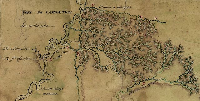
English: Detail of a French map depicting what today is the Memphis, Tennessee area.
"This map of the Mississippi River Valley from Memphis to the Gulf of Mexico as far east as Mobile includes interior streams, routes, European communities, and Native American settlements and nations, fortifications ... Map concentrates on the surveys of Broutin, Vergés, and Saucier in Mississippi and Alabama ..." Map is a digital copy from the U.S. Library of Congress. |
||||||
| Date | |||||||
| Source | http://hdl.loc.gov/loc.gmd/g4010.ct000681 | ||||||
| Author | Louisiana and Mississippi routes of Broutin, de Verges, and Saucier, author unknown. | ||||||
| Permission (Reusing this file) |
|


File history
Click on a date/time to view the file as it appeared at that time.
| Date/Time | Thumbnail | Dimensions | User | Comment | |
|---|---|---|---|---|---|
| current | 00:38, 29 June 2009 | | 1,233 × 624 (674 KB) | DoxTxob | {{Information |Description={{en|1=Detail of a French map depicting what today is the Memphis, Tennessee area. "This map of the Mississippi River Valley from Memphis to the Gulf of Mexico as far east as Mobile includes interior streams, routes, European c |
File usage
The following pages on the English Wikipedia use this file (pages on other projects are not listed):
Global file usage
The following other wikis use this file:
- Usage on arz.wikipedia.org
- Usage on de.wikipedia.org
- Usage on es.wikipedia.org
- Usage on fr.wikipedia.org
- Usage on www.wikidata.org