
File:FortTravis.jpg

Original file (3,411 × 2,338 pixels, file size: 2.07 MB, MIME type: image/jpeg)
| This is a file from the Wikimedia Commons. Information from its description page there is shown below. Commons is a freely licensed media file repository. You can help. |
|
This is an image of a place or building that is listed on the National Register of Historic Places in the United States of America. Its reference number is 05000247. |
Summary
| Description |
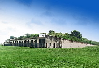
English: Fort Travis on Bolivar Peninsula |
| Date | |
| Source | Own work |
| Author | Jim Evans |
Fort Travis is on Bolivar Peninsula off the East end of Galveston Island.
The first Fort Travis, on the eastern end of Galveston Island, was the first fort established by the Republic of Texas in 1836 to protect the entrance to Galveston harbor. The first Fort is no longer standing and was later built across the harbor on Bolivar Peninsula where construction began in 1898 and continued until WWII
| Camera location | | View this and other nearby images on: OpenStreetMap |
|---|
Licensing
- You are free:
- to share – to copy, distribute and transmit the work
- to remix – to adapt the work
- Under the following conditions:
- attribution – You must give appropriate credit, provide a link to the license, and indicate if changes were made. You may do so in any reasonable manner, but not in any way that suggests the licensor endorses you or your use.
- share alike – If you remix, transform, or build upon the material, you must distribute your contributions under the same or compatible license as the original.

|
This image has been assessed under the valued image criteria and is considered the most valued image on Commons within the scope: Fort Travis. You can see its nomination here. |
File history
Click on a date/time to view the file as it appeared at that time.
| Date/Time | Thumbnail | Dimensions | User | Comment | |
|---|---|---|---|---|---|
| current | 17:24, 13 May 2018 | | 3,411 × 2,338 (2.07 MB) | Jim Evans | larger image |
| 21:34, 17 May 2015 |  | 2,200 × 1,508 (997 KB) | Jim Evans | User created page with UploadWizard |
File usage
Global file usage
The following other wikis use this file:
- Usage on de.wikipedia.org
- Usage on en.wikivoyage.org
- Usage on fr.wikipedia.org
- Usage on www.wikidata.org