
File:Finchmap.jpg
Size of this preview: 566 × 600 pixels. Other resolutions: 226 × 240 pixels | 569 × 603 pixels.
Original file (569 × 603 pixels, file size: 97 KB, MIME type: image/jpeg)
| This is a file from the Wikimedia Commons. Information from its description page there is shown below. Commons is a freely licensed media file repository. You can help. |
| Description |
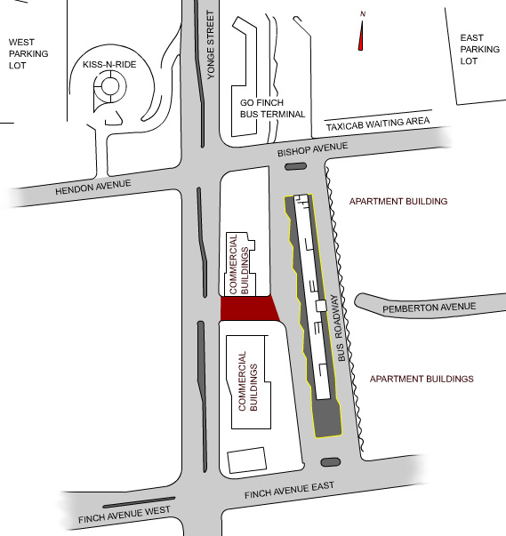
English: A map of the Finch subway station bus terminal and surrounding facilities in Toronto, Canada. The maroon path is the Pemberton exit completed by the end of 2006. The terminal is the facility in the middle-right of the image.
The map was drawn from scratch by me, based on a press release diagram from the Toronto Transit Commission, and satellite photos from Google. TheHYPO 09:22, 12 June 2006 (UTC) |
||
| Date | |||
| Source | Transferred from en.wikipedia. | ||
| Author | en:User:TheHYPO | ||
| Permission (Reusing this file) |
|
Original upload log
The original description page is/was here. All following user names refer to en.wikipedia.
- 2006-06-12 10:28 TheHYPO 569×603 (97 KB)
File history
Click on a date/time to view the file as it appeared at that time.
| Date/Time | Thumbnail | Dimensions | User | Comment | |
|---|---|---|---|---|---|
| current | 14:49, 29 July 2010 | | 569 × 603 (97 KB) | Voyager | {{Information |Description={{en|A map of the Finch subway station bus terminal and surrounding facilities in Toronto, Canada. The maroon path is the Pemberton exit completed by the end of 2006. The terminal is the facility in the middle-right of the image |
File usage
The following pages on the English Wikipedia use this file (pages on other projects are not listed):
Global file usage
The following other wikis use this file:
- Usage on de.wikipedia.org
- Usage on fa.wikipedia.org
- Usage on ko.wikipedia.org