
File:FederationOfSouthArabiaMap.jpg
Size of this preview: 800 × 506 pixels. Other resolutions: 320 × 202 pixels | 640 × 405 pixels | 1,024 × 648 pixels | 1,280 × 809 pixels | 2,282 × 1,443 pixels.
Original file (2,282 × 1,443 pixels, file size: 361 KB, MIME type: image/jpeg)
| This is a file from the Wikimedia Commons. Information from its description page there is shown below. Commons is a freely licensed media file repository. You can help. |
Summary

|
File:Federation of South Arabia constituents map - ru.svg is a vector version of this file. It should be used in place of this JPG file when not inferior.
File:FederationOfSouthArabiaMap.jpg → File:Federation of South Arabia constituents map - ru.svg
For more information, see Help:SVG. |
 |
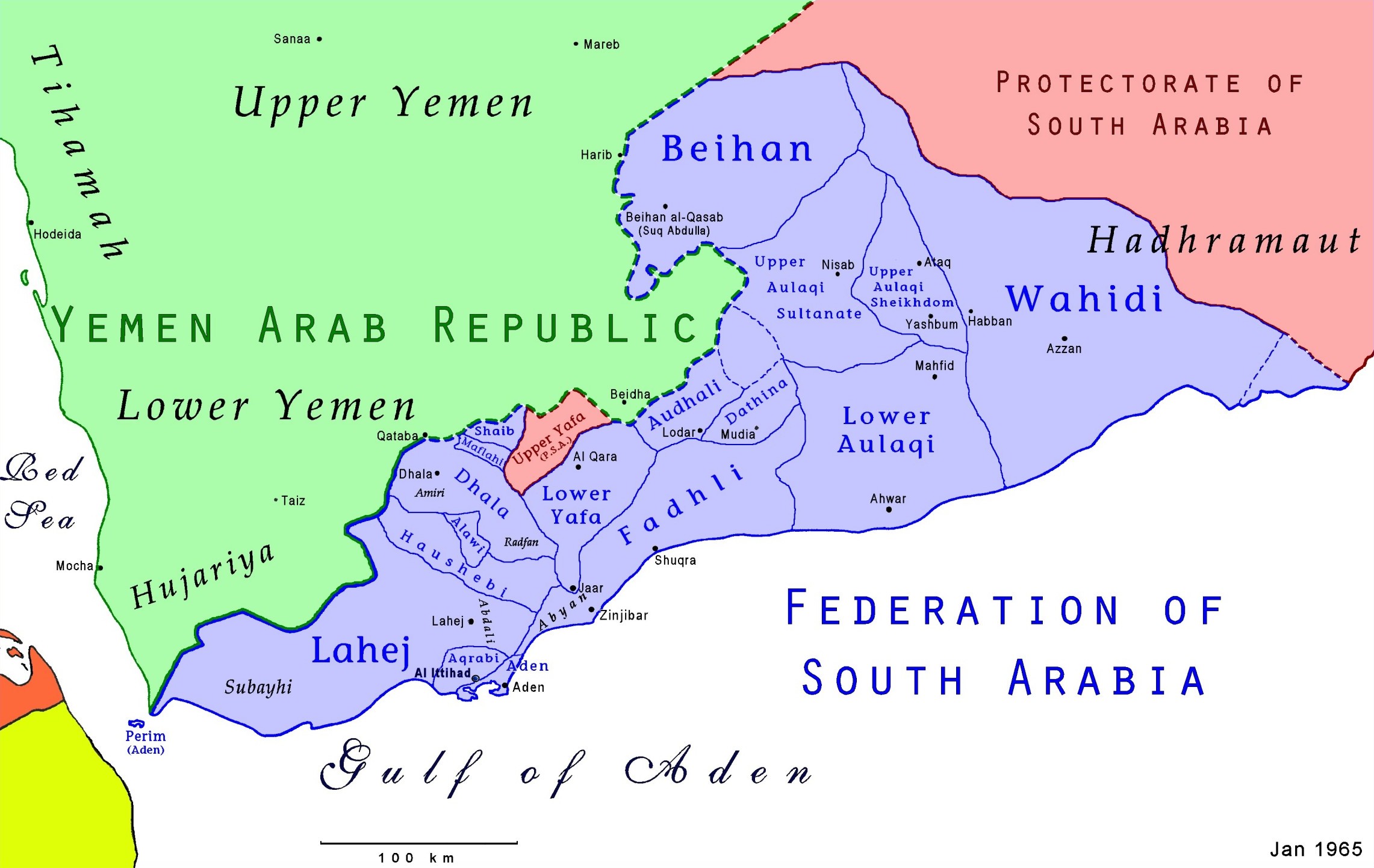
Map of the Federation of South Arabia in present-day Yemen. Uploader is author; based on US Dept of the Army information
Licensing

|
The copyright holder of this image hereby irrevocably releases all rights to it, allowing it to be freely reproduced, distributed, transmitted, used, modified, built upon, or otherwise exploited in any way by anyone for any purpose, commercial or non-commercial. However, as a courtesy, a link back to Wikipedia (http://www.wikipedia.org/) would be appreciated.
|
This work is in the public domain in the United States because it is a work prepared by an officer or employee of the United States Government as part of that person’s official duties under the terms of Title 17, Chapter 1, Section 105 of the US Code.
Note: This only applies to original works of the Federal Government and not to the work of any individual U.S. state, territory, commonwealth, county, municipality, or any other subdivision. This template also does not apply to postage stamp designs published by the United States Postal Service since 1978. (See § 313.6(C)(1) of Compendium of U.S. Copyright Office Practices). It also does not apply to certain US coins; see The US Mint Terms of Use.
|
 | |
| This file has been identified as being free of known restrictions under copyright law, including all related and neighboring rights. | ||
File history
Click on a date/time to view the file as it appeared at that time.
| Date/Time | Thumbnail | Dimensions | User | Comment | |
|---|---|---|---|---|---|
| current | 22:39, 31 July 2021 | | 2,282 × 1,443 (361 KB) | AjaxSmack | Reverted to version as of 02:00, 18 January 2010 (UTC) |
| 09:09, 25 July 2019 |  | 2,600 × 2,245 (584 KB) | Havsjö | clearer | |
| 02:00, 18 January 2010 |  | 2,282 × 1,443 (361 KB) | Anonimosanhueza | borders removed | |
| 22:56, 17 December 2006 |  | 2,297 × 1,459 (413 KB) | Electionworld | {{ew|en|AjaxSmack}} == Summary == Map of the {{link|Federation of South Arabia}} in present-day {{link|Yemen}}. Uploader is author; based on US Dept of the Army information {{CopyrightedFreeUse-Link}} == Licensing == {{PD-USGov}} |
File usage
The following pages on the English Wikipedia use this file (pages on other projects are not listed):
- Al-Busi
- Al-Dhubi
- Alawi Sheikhdom
- Aqrabi
- Audhali
- Dathina
- Emirate
- Emirate of Beihan
- Emirate of Dhala
- Fadhli Sultanate
- Federation of South Arabia
- Federation of the Emirates of South Arabia
- Hadrami sheikhdom
- Haushabi
- Lower Aulaqi Sultanate
- Lower Yafa
- Maflahi
- Mawsata
- Radfan
- Shaib
- Subeihi
- Sultanate of Lahej
- Upper Aulaqi Sheikhdom
- Upper Aulaqi Sultanate
- Wahidi
- Wahidi Balhaf
- Wahidi Bir Ali
- Wahidi Haban
- User talk:Fastifex
- Wikipedia:Graphics Lab/Map workshop/Archive/Mar 2010
Global file usage
The following other wikis use this file:
- Usage on ar.wikipedia.org
- Usage on azb.wikipedia.org
- Usage on be.wikipedia.org
- Usage on bn.wikipedia.org
- Usage on ca.wikipedia.org
- Usage on cs.wikipedia.org
- Usage on de.wikipedia.org
- Usage on es.wikipedia.org
View more global usage of this file.