
File:Fallon South 2 MOA.png

Size of this preview: 800 × 327 pixels. Other resolutions: 320 × 131 pixels | 640 × 262 pixels | 1,420 × 581 pixels.
Original file (1,420 × 581 pixels, file size: 1.76 MB, MIME type: image/png)
| This is a file from the Wikimedia Commons. Information from its description page there is shown below. Commons is a freely licensed media file repository. You can help. |
Summary
| Description |
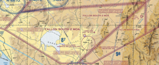
English: a depiction of the Fallon 2 South w:Millitary Operations Area, near w:Fallon Air Station, on a VFR map |
| Date | |
| Source | vfrmap.com/FAA |
| Author | FAA |
| Camera location | | View this and other nearby images on: OpenStreetMap |
|---|
Licensing
This image or file is a work of a Federal Aviation Administration employee, taken or made as part of that person's official duties. As a work of the U.S. federal government, the image is in the public domain in the United States.
|
 |
File history
Click on a date/time to view the file as it appeared at that time.
| Date/Time | Thumbnail | Dimensions | User | Comment | |
|---|---|---|---|---|---|
| current | 00:10, 17 October 2023 | 1,420 × 581 (1.76 MB) | Lomrjyo | Uploaded a work by FAA from vfrmap.com/FAA with UploadWizard |
File usage
The following pages on the English Wikipedia use this file (pages on other projects are not listed):
Global file usage
The following other wikis use this file:
- Usage on ar.wikipedia.org
- Usage on fa.wikipedia.org