
File:Fallen Timbers Battlefield.jpg

Size of this preview: 800 × 600 pixels. Other resolutions: 320 × 240 pixels | 640 × 480 pixels | 1,024 × 768 pixels | 1,280 × 960 pixels | 2,560 × 1,920 pixels | 2,816 × 2,112 pixels.
Original file (2,816 × 2,112 pixels, file size: 3.3 MB, MIME type: image/jpeg)
| This is a file from the Wikimedia Commons. Information from its description page there is shown below. Commons is a freely licensed media file repository. You can help. |
|
This is an image of a place or building that is listed on the National Register of Historic Places in the United States of America. Its reference number is 66000616. |
| Camera location | | View this and other nearby images on: OpenStreetMap |
|---|
| Description |
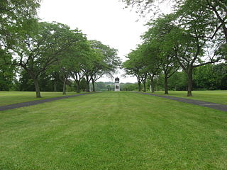
English: Overview of the Fallen Timbers Battlefield, where the Battle of Fallen Timbers was fought in 1794. Located off U.S. Route 24 in Monclova Township, Lucas County, Ohio, United States, it has been designated a National Historic Landmark. |
||
| Date | Taken on 31 July 2010 | ||
| Source | Own work | ||
| Author | Nyttend | ||
| Permission (Reusing this file) |
|
File history
Click on a date/time to view the file as it appeared at that time.
| Date/Time | Thumbnail | Dimensions | User | Comment | |
|---|---|---|---|---|---|
| current | 22:21, 4 August 2010 | | 2,816 × 2,112 (3.3 MB) | Nyttend | {{Location|41|32|38.4|N|83|41|51|W}} {{Information |Description={{en|Overview of the {{w|Fallen Timbers Battlefield}}, where the {{w|Battle of Fallen Timbers}} was fought in 1794. Located off {{w|U.S. Route 24}} in {{w|Monclova Township, Lucas County, Oh |
File usage
The following pages on the English Wikipedia use this file (pages on other projects are not listed):
Global file usage
The following other wikis use this file:
- Usage on ceb.wikipedia.org
- Usage on en.wikivoyage.org
- Usage on es.wikipedia.org
- Usage on eu.wikipedia.org
- Usage on fa.wikipedia.org
- Usage on fr.wikipedia.org
- Usage on it.wikivoyage.org
- Usage on pl.wikivoyage.org
- Usage on pt.wikipedia.org
- Usage on vi.wikipedia.org
- Usage on www.wikidata.org
- Usage on zh.wikipedia.org