
File:Fabien 2023-05-17 0200Z colored.jpg

Size of this preview: 465 × 600 pixels. Other resolutions: 186 × 240 pixels | 372 × 480 pixels | 595 × 768 pixels | 793 × 1,024 pixels | 1,550 × 2,000 pixels.
Original file (1,550 × 2,000 pixels, file size: 2.31 MB, MIME type: image/jpeg)
| This is a file from the Wikimedia Commons. Information from its description page there is shown below. Commons is a freely licensed media file repository. You can help. |
Summary
| Description |
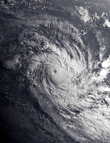
English: This colored visible image of Intense Tropical Cyclone Fabien over the high seas of the Indian Ocean was captured on the morning of 17 May 2023 at 02:00 UTC, shortly after sunrise, by the Spinning Enhanced Visible and InfraRed Imager (SEVIRI) instrument flying aboard EUMETSAT's Meteosat 9 satellite. Fabien was a relatively intense late-season tropical cyclone, and it was the tenth depression, tenth named or namable storm, and third intense tropical cyclone of the 2022-23 South-West Indian Ocean cyclone season. When this image was taken, Fabien was coming off its peak intensity and was located near the British Indian Ocean Territory. The intensity of the cyclone when this image was taken was winds of 170 km/h (105 mph) (90 knots) on the 10-min Météo-France cyclone scale, making it an "Intense Tropical Cyclone" on the scale, and according to the Joint Typhoon Warning Center, it had 1-min sustained winds of 175 km/h (110 mph) (95 knots) making it equivalent to a "Category 3 major hurricane," on the Saffir-Simpson Hurricane Wind Scale, the official minimum central pressure (provided by the MFR) was at or around 962 mbar (28.4 inHg). |
| Date | |
| Source | RealEarth™ (Satellite data) EOSDIS Worldview (Background data) |
| Author | The University of Wisconsin-Madison, Space Science and Engineering Center/ SEVIRI imagery from EUMETSAT's Meteosat 9 Satellite/NASA |
Licensing
This image was produced by the European Organisation for the Exploitation of Meteorological Satellites. The legal information (archive) stated that all the images published on their website can be used, downloaded and copied, as long as the source is acknowledged.
As of 15 January 2019, please do not use this licence as EUMETSAT's copyright policy has changed. (See this.)
|

This image was produced by the SSEC/CIMSS, University of Wisconsin–Madison. All the images published on their website can be freely used, as long as the source is acknowledged. (disclaimer (archive))
|
 |
| This file is in the public domain in the United States because it was solely created by NASA. NASA copyright policy states that "NASA material is not protected by copyright unless noted". (See Template:PD-USGov, NASA copyright policy page or JPL Image Use Policy.) | ||
 |
Warnings:
|
File history
Click on a date/time to view the file as it appeared at that time.
| Date/Time | Thumbnail | Dimensions | User | Comment | |
|---|---|---|---|---|---|
| current | 22:32, 18 May 2023 | | 1,550 × 2,000 (2.31 MB) | TheWxResearcher | Uploaded a work by The University of Wisconsin-Madison, Space Science and Engineering Center/ SEVIRI imagery from EUMETSAT's Meteosat 9 Satellite/NASA from [https://realearth.ssec.wisc.edu/ RealEarth™] (Satellite data) [https://worldview.earthdata.nasa.gov/ EOSDIS Worldview] (Background data) with UploadWizard |
File usage
The following pages on the English Wikipedia use this file (pages on other projects are not listed):
Global file usage
The following other wikis use this file:
- Usage on de.wikipedia.org
- Usage on zh.wikipedia.org