
File:Evariste Huc carte voyage clear.png

Size of this preview: 738 × 600 pixels. Other resolutions: 295 × 240 pixels | 591 × 480 pixels | 903 × 734 pixels.
Original file (903 × 734 pixels, file size: 549 KB, MIME type: image/png)
| This is a file from the Wikimedia Commons. Information from its description page there is shown below. Commons is a freely licensed media file repository. You can help. |
Summary
| Description |
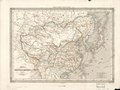
English: A clear version of a small French National Library scan of Dufour's 1840 "Map of China and Its Tributary States", used in Huc's 1853 2nd edition of his Remembrances of a Voyage in Tartary, Tibet, and China during the Years 1844, 1845, and 1846 with a dark line tracing the route of Huc and his fellow missionary Joseph Gabet. Note that this line is correct and includes his sea voyages, as opposed to the erroneous route traced in the 1st edition which confused Huc's route with Dufour's illustration of the Grand Canal. The Yellow River is still shown following its lower course from before the massive floods of the 1850s. Shanghai is entirely omitted as less important than Hangzhou (Hang-tcheou), Suzhou (Sou-tcheou), and Songjiang (Song-kiang, entirely misplaced to the north bank of the Yangtze). Some important places along Huc's route have been marked in the map and noted in a legend at the bottom of the page. Note that Huc & Gabet did not carry Dufour's map but one of those printed by Andriveau-Goujon like this. |
| Date | |
| Source | Souvenirs d'un Voyage dans la Tartarie, le Thibet, et la Chine pendant les Années 1844, 1845, et 1846, 2nd ed., Vol. I, p. 4. |
| Author | Unclear, from an original map by Auguste-Henri Dufour |
| Other versions |
|


Licensing
|
This work is in the public domain in its country of origin and other countries and areas where the copyright term is the author's life plus 70 years or fewer. This work is in the public domain in the United States because it was published (or registered with the U.S. Copyright Office) before January 1, 1929. | |
| This file has been identified as being free of known restrictions under copyright law, including all related and neighboring rights. | |
This work is based on a work in the public domain. It has been digitally enhanced and/or modified. This derivative work has been (or is hereby) released into the public domain by its author, LlywelynII. This applies worldwide.
In some countries this may not be legally possible; if so: |
File history
Click on a date/time to view the file as it appeared at that time.
| Date/Time | Thumbnail | Dimensions | User | Comment | |
|---|---|---|---|---|---|
| current | 03:51, 30 July 2019 | | 903 × 734 (549 KB) | LlywelynII | User created page with UploadWizard |
File usage
The following pages on the English Wikipedia use this file (pages on other projects are not listed):
Global file usage
The following other wikis use this file:
- Usage on fr.wikipedia.org
- Usage on fr.wikisource.org
- Usage on ro.wikipedia.org
- Usage on ru.wikipedia.org