
File:Eva-archaic-site-profile-tn1.jpg
No higher resolution available.
Eva-archaic-site-profile-tn1.jpg (421 × 234 pixels, file size: 15 KB, MIME type: image/jpeg)
| This is a file from the Wikimedia Commons. Information from its description page there is shown below. Commons is a freely licensed media file repository. You can help. |


Summary
| Description |
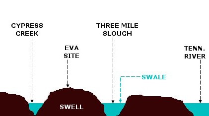
A profile diagram of the floodplain upon which the Eva archaic site was located. Before the completion of Kentucky Dam inundated the site in 1944, the floodplain was characterized by a "swell-and-swale" topography. Swales are ancient river channels and tributary channels that are still filled with water, whereas swells are natural levees created by soil deposits from these ancient streams. The Tennessee River originally flowed through Three Mile Slough. This diagram is based on the description of the site given by Lewis and Lewis: Eva, an Archaic site, 1-4 (1961). NOT drawn to scale. |
| Date | |
| Source | Own work |
| Author | Brian Stansberry |
Licensing
I, the copyright holder of this work, hereby publish it under the following licenses:

|
Permission is granted to copy, distribute and/or modify this document under the terms of the GNU Free Documentation License, Version 1.2 or any later version published by the Free Software Foundation; with no Invariant Sections, no Front-Cover Texts, and no Back-Cover Texts. A copy of the license is included in the section entitled GNU Free Documentation License. |
This file is licensed under the Creative Commons Attribution 3.0 Unported license.
- You are free:
- to share – to copy, distribute and transmit the work
- to remix – to adapt the work
- Under the following conditions:
- attribution – You must give appropriate credit, provide a link to the license, and indicate if changes were made. You may do so in any reasonable manner, but not in any way that suggests the licensor endorses you or your use.
You may select the license of your choice.
File history
Click on a date/time to view the file as it appeared at that time.
| Date/Time | Thumbnail | Dimensions | User | Comment | |
|---|---|---|---|---|---|
| current | 20:56, 17 March 2008 | | 421 × 234 (15 KB) | BrineStans | {{Information |Description=A profile diagram of the floodplain upon which the Eva archaic site was located. Before the completion of Kentucky Dam inundated the site in 1944, the floodplain was characterized by a "swell-and-swale" topography. Swales are |
File usage
The following pages on the English Wikipedia use this file (pages on other projects are not listed):