
File:European railtrafficregions.png
Size of this preview: 683 × 599 pixels. Other resolutions: 274 × 240 pixels | 547 × 480 pixels | 891 × 782 pixels.
Original file (891 × 782 pixels, file size: 28 KB, MIME type: image/png)
| This is a file from the Wikimedia Commons. Information from its description page there is shown below. Commons is a freely licensed media file repository. You can help. |
| Description |
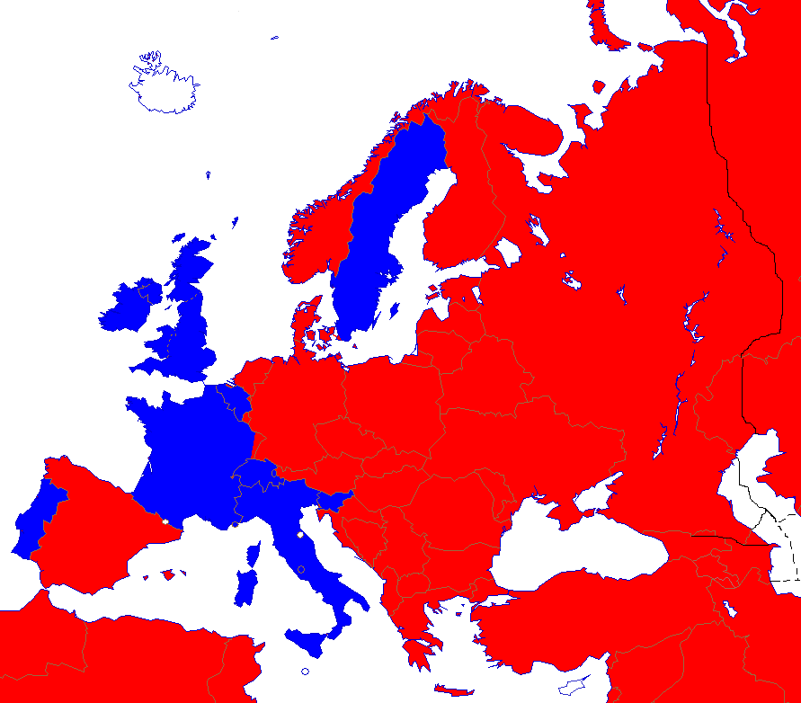
English: Right- and left-hand traffic on European railways.
Right-hand traffic Left-hand traffic No railway Svenska: Höger- och vänstertrafik på järnvägar i Europa. Högertrafik Vänstertrafik Inga järnvägar |
||||||||
| Date | |||||||||
| Source | Wikipedia | ||||||||
| Author | Paul Schlyter | ||||||||
| Permission (Reusing this file) |
|
||||||||
| Other versions |
File:European_trafficregions.png |


|
This map of europe image could be re-created using vector graphics as an SVG file. This has several advantages; see Commons:Media for cleanup for more information. If an SVG form of this image is available, please upload it and afterwards replace this template with
{{vector version available|new image name}}.
It is recommended to name the SVG file “European railtrafficregions.svg”—then the template Vector version available (or Vva) does not need the new image name parameter. |
File history
Click on a date/time to view the file as it appeared at that time.
| Date/Time | Thumbnail | Dimensions | User | Comment | |
|---|---|---|---|---|---|
| current | 22:06, 23 August 2022 | | 891 × 782 (28 KB) | Рагин1987 | More correct visualization of the dividing line on the territory of the Caucasus Range |
| 16:24, 15 December 2017 |  | 891 × 782 (44 KB) | A2D2 | The Vatican city has railways and uses the left just like Italy, even though it is only a few hundred meters long and is very rarely used. | |
| 20:30, 18 January 2017 |  | 891 × 782 (44 KB) | BIL | Spain uses right. Austria also to much higher degree since 2012. Monaco uses left. A corner of France and Sweden diverge use their neighbour's side. Channel tunnel and Oresund Bridge added. Slightly cropped so that Svalbard and Turkmenistan are excluded. | |
| 14:22, 1 September 2008 |  | 942 × 917 (44 KB) | Pausch | {{Information/sv |Beskrivning = Höger/vänstertrafik på järnvägar i Europa |Källa = Wikipedia |Datum = 2008-09-01 |Skapare = Paul Schlyter |Rättigheter = GFDL |Andra_versioner = European_trafficregions.png }} Category:Järnvägar <!--{{ImageUpl |
File usage
The following pages on the English Wikipedia use this file (pages on other projects are not listed):
Global file usage
The following other wikis use this file:
- Usage on es.wikipedia.org
- Usage on et.wikipedia.org
- Usage on hu.wikipedia.org
- Usage on id.wikipedia.org
- Usage on mk.wikipedia.org
- Usage on no.wikipedia.org
- Usage on ru.wikipedia.org
- Usage on sv.wikipedia.org
- Usage on www.wikidata.org