File:Europe geological map-en.svg

Page contents not supported in other languages.
This is a file from the Wikimedia Commons
From Wikipedia, the free encyclopedia

Original file(SVG file, nominally 5,408 × 5,504 pixels, file size: 28.8 MB)

Summary

Description
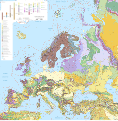
English: Map in English of the surficial geology of Europe.

Notes:

  • The background map is a raster PNG image embedded in the SVG file.
  • Due to its heavy file-weight, this version is only intended to be used for working purposes like translations. For use in article pages consider the JPEG version.
  • Each geology province is classified and named in the XML code of the SVG file.
  • A list of the names corresponding to the geologic provinces codes displayed on the map can be viewed on the discussion page.


Français : Carte en anglais de la géologie de surface de l'Europe.

Notes :

  • Le fond de carte est une image bitmap PNG embarquée dans le fichier SVG.
  • En raison du poids important du fichier, cette carte n'est destinée qu'aux travaux, comme par exemple les traductions. Pour l'utilisation dans les pages d'articles préférer la version JPEG.
  • Chaque province géologique est classée et nommée dans le code XML du fichier SVG.
  • Une liste des noms anglophones correspondant aux codes des provinces géologiques de la carte peut être consultée sur la page de discussion.

Lambert Azimuthal Equal-Area projection - ETRS89 datum

Scale 1:5,000,000
Date
Source

Own work

  • Sources of data:
    • USGS (public domain for the part of the data used)
    • International political boundaries and additional coastlines: NGDC World Coast Line (public domain)
Author Eric Gaba (Sting - fr:Sting)
Permission
(Reusing this file)
Attribution and Share-Alike required
Other versions


Translate this file This SVG file contains embedded text that can be translated into your language, using any capable SVG editor, text editor or the SVG Translate tool. For more information see: About translating SVG files.

Licensing

Eric Gaba, Wikimedia Commons user Sting, the copyright holder of this work, hereby publishes it under the following license:
w:en:Creative Commons
attribution share alike
This file is licensed under the Creative Commons Attribution-Share Alike 3.0 Unported license.
Attribution: Eric Gaba, Wikimedia Commons user Sting
You are free:
  • to share – to copy, distribute and transmit the work
  • to remix – to adapt the work
Under the following conditions:
  • attribution – You must give appropriate credit, provide a link to the license, and indicate if changes were made. You may do so in any reasonable manner, but not in any way that suggests the licensor endorses you or your use.
  • share alike – If you remix, transform, or build upon the material, you must distribute your contributions under the same or compatible license as the original.

Captions

Add a one-line explanation of what this file represents

Items portrayed in this file

depicts

August 2010

File history

Click on a date/time to view the file as it appeared at that time.

Date/TimeThumbnailDimensionsUserComment
current17:48, 13 August 2010Thumbnail for version as of 17:48, 13 August 20105,408 × 5,504 (28.8 MB)Sting== {{int:filedesc}} == {{Location|60|00|00|N|20|00|00|E|scale:20000000}} <br/> {{Information| |Description={{en|Map in English of the surficial geology of Europe.<br/>''Notes: The background map is a raster PNG image embedded in
The following pages on the English Wikipedia use this file (pages on other projects are not listed):

Global file usage

The following other wikis use this file: