
File:Europe20000ya.png

Size of this preview: 800 × 532 pixels. Other resolutions: 320 × 213 pixels | 640 × 426 pixels | 1,024 × 681 pixels | 1,280 × 852 pixels | 1,900 × 1,264 pixels.
Original file (1,900 × 1,264 pixels, file size: 98 KB, MIME type: image/png)
| This is a file from the Wikimedia Commons. Information from its description page there is shown below. Commons is a freely licensed media file repository. You can help. |
Summary
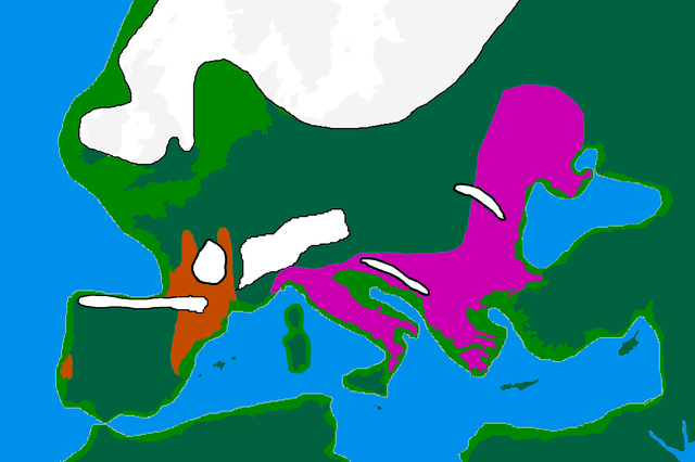
| Description | map of Europe 20,000 years ago. |
| Date | |
| Source |
made by me from Image:BlankMap-Europe-v3.png, which is GFDL v1.2, outline of ancient coast and extent of ice added by me from information from "After the Ice: A Global History" by Steve Mithen. Information about human refugia from "Origins of the British" by Stephen Oppenheimer and "Out of Eden by Stephen Oppenheimer. These were sketched in by me from information supplied by these books. Coloured areas are the furthest extent of the cultures between 15 kya and 20 kya. Solutrean and Proto Solutrean Cultures; Franco-Cantabrian region
Epi Gravettian Culture |
| Author | User:Wobble |
| Permission (Reusing this file) |
GFDL |
Licensing

|
Permission is granted to copy, distribute and/or modify this document under the terms of the GNU Free Documentation License, Version 1.2 or any later version published by the Free Software Foundation; with no Invariant Sections, no Front-Cover Texts, and no Back-Cover Texts. A copy of the license is included in the section entitled GNU Free Documentation License. |
| This file is licensed under the Creative Commons Attribution-Share Alike 3.0 Unported license. | ||
| ||
| This licensing tag was added to this file as part of the GFDL licensing update. |
File history
Click on a date/time to view the file as it appeared at that time.
| Date/Time | Thumbnail | Dimensions | User | Comment | |
|---|---|---|---|---|---|
| current | 16:00, 12 April 2007 | | 1,900 × 1,264 (98 KB) | Wobble | Reverted to earlier revision |
| 15:59, 12 April 2007 |  | 1,000 × 665 (106 KB) | Wobble | Reverted to earlier revision | |
| 15:50, 12 April 2007 |  | 1,900 × 1,264 (98 KB) | Wobble | better version, shows refugia better, from Oppenheimer, Out of Eden | |
| 08:13, 28 March 2007 |  | 1,000 × 665 (106 KB) | Dbachmann | shrunk; accounting for Black Sea flood. | |
| 18:59, 25 February 2007 |  | 1,900 × 1,264 (129 KB) | Wobble | {{Information |Description=map of Europe 20,000 years ago. |Source=made from Image:BlankMap-Europe-v3.png, which is GFDL v1.2 by me, outline of coast and extent of ice added by me from information from "After the Ice: A GLoba History" by Steve Mithen. |
File usage
The following pages on the English Wikipedia use this file (pages on other projects are not listed):
- Cro-Magnon
- Epigravettian
- Europe
- Genetic history of Europe
- Haplogroup I-M170
- Last Glacial Maximum
- Last Glacial Maximum refugia
- Refugium (population biology)
- River Thames
- Upper Paleolithic
- Western Hunter-Gatherer
- User:Baum019/Last Glacial Maximum refugia
- User:Bongan/genetic history of the human race
- User:Hans Adler/Sandbox
- User:Swid/Sandbox
- User:Wobble/images
Global file usage
The following other wikis use this file:
- Usage on ar.wikipedia.org
- Usage on bs.wikipedia.org
- Usage on ca.wikipedia.org
- Usage on cs.wikipedia.org
- Usage on de.wikipedia.org
- Usage on en.wikiversity.org
- Usage on eo.wikipedia.org
- Usage on es.wikipedia.org
- Usage on eu.wikipedia.org
- Usage on fa.wikipedia.org
- Usage on fi.wikipedia.org
- Usage on fr.wikipedia.org
- Usage on it.wikipedia.org
- Usage on ja.wikipedia.org
- Usage on lt.wikipedia.org
- Usage on lv.wikipedia.org
- Usage on mk.wikipedia.org
- Usage on nl.wikipedia.org
- Usage on no.wikipedia.org
- Usage on pt.wikipedia.org
- Usage on ru.wikipedia.org
View more global usage of this file.