
File:Europe-south-west-kingdoms.png
No higher resolution available.
Europe-south-west-kingdoms.png (531 × 422 pixels, file size: 235 KB, MIME type: image/png)
| This is a file from the Wikimedia Commons. Information from its description page there is shown below. Commons is a freely licensed media file repository. You can help. |
Summary
| Description |
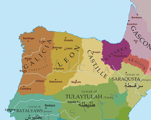
English: Political map of the northwest of the Iberian Peninsula at the end of the 11th century.
Deutsch: Politische Karte des Nordwestens der Iberischen Halbinsel Ende des 11. Jahrhunderts.
Français : Carte politique du nord-ouest de la péninsule ibérique à la fin du XIe siècle.
Galego: Mapa político do noroeste da Península Ibérica a finais do século XI.
Nederlands: Politieke kaart van het noordwesten van het Iberisch schiereiland aan het einde van de 11e eeuw. |
| Date | 20 March 2009 (original upload date) |
| Source | Transferred from gl.wikipedia to Commons. |
| Author | The original uploader was Alexandre Vigo at Galician Wikipedia. |
Licensing

|
Permission is granted to copy, distribute and/or modify this document under the terms of the GNU Free Documentation License, Version 1.2 or any later version published by the Free Software Foundation; with no Invariant Sections, no Front-Cover Texts, and no Back-Cover Texts. A copy of the license is included in the section entitled GNU Free Documentation License. |
| This file is licensed under the Creative Commons Attribution-Share Alike 3.0 Unported license. | ||
| ||
| This licensing tag was added to this file as part of the GFDL licensing update. |
Original upload log
The original description page was here. All following user names refer to gl.wikipedia.
- 2009-03-20 22:59 Alexandre Vigo 531×422× (241008 bytes) Descrición/Description: Mapa político do noroeste da Península Ibérica a finais do século XI. Orixe/Source: Traballo propio. Autor/Author: Atoría propia Copyright: Contido GFDL creado polo que carga o ficheiro. Data/Date: 20/03/09 Outras versións/O
File history
Click on a date/time to view the file as it appeared at that time.
| Date/Time | Thumbnail | Dimensions | User | Comment | |
|---|---|---|---|---|---|
| current | 20:17, 3 January 2019 | | 531 × 422 (235 KB) | One2 | Reverted to version as of 23:44, 21 March 2009 (UTC). About Alfonso VI: Pope Urban II -> Regi Ildefonso Gallitia, William of Malmesbury -> Gallicae Regie, Orderic Vitalis -> rex Galliciae. |
| 20:54, 13 May 2012 |  | 531 × 422 (264 KB) | Agricolae | remove inaccurate label of Galicia over entire north | |
| 23:44, 21 March 2009 |  | 531 × 422 (235 KB) | Elvire | {{Information |Description={{gl|Mapa político do noroeste da Península Ibérica a finais do século XI.}} {{fr|Carte politique du nord-ouest de la péninsule ibérique à la fin du XI ème siècle.}} |Source=Transferred from [http://gl.wikipedia.org gl. |
File usage
The following pages on the English Wikipedia use this file (pages on other projects are not listed):
Global file usage
The following other wikis use this file:
- Usage on ar.wikipedia.org
- Usage on azb.wikipedia.org
- Usage on br.wikipedia.org
- Usage on de.wikipedia.org
- Usage on es.wikipedia.org
- Usage on fi.wikipedia.org
- Usage on fr.wikipedia.org
- Usage on gl.wikipedia.org
- Usage on id.wikipedia.org
- Usage on it.wikipedia.org
- Usage on ms.wikipedia.org
- Usage on nl.wikipedia.org
- Usage on pt.wikipedia.org
- Usage on ru.wikipedia.org
- Usage on sl.wikipedia.org
- Usage on th.wikipedia.org
- Usage on uk.wikipedia.org
- Usage on zh.wikipedia.org
View more global usage of this file.