
File:Europa Ludwigskanal Rhein Main Donau.png
No higher resolution available.
Europa_Ludwigskanal_Rhein_Main_Donau.png (715 × 444 pixels, file size: 69 KB, MIME type: image/png)
| This is a file from the Wikimedia Commons. Information from its description page there is shown below. Commons is a freely licensed media file repository. You can help. |

|
This map image could be re-created using vector graphics as an SVG file. This has several advantages; see Commons:Media for cleanup for more information. If an SVG form of this image is available, please upload it and afterwards replace this template with
{{vector version available|new image name}}.
It is recommended to name the SVG file “Europa Ludwigskanal Rhein Main Donau.svg”—then the template Vector version available (or Vva) does not need the new image name parameter. |
| Description |
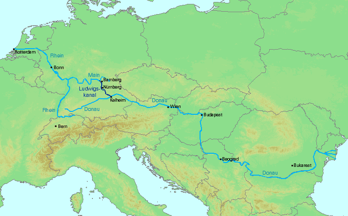
Deutsch: Karte, die den de:Ludwigskanal im europäischen Kontext auf der Linie de:Rotterdam – de:Schwarzes Meer einordnet.
English: Map showing the Ludwigs Canal in the european context on the route en:Rotterdam – en:Black Sea. |
| Date | |
| Source | Own work. Background map made with http://www2.demis.nl/mapserver/mapper.asp. |
| Author | jailbird |

|
Permission is granted to copy, distribute and/or modify this document under the terms of the GNU Free Documentation License, Version 1.2 or any later version published by the Free Software Foundation; with no Invariant Sections, no Front-Cover Texts, and no Back-Cover Texts. A copy of the license is included in the section entitled GNU Free Documentation License. |
| This file is licensed under the Creative Commons Attribution-Share Alike 3.0 Unported license. | ||
| ||
| This licensing tag was added to this file as part of the GFDL licensing update. |
File history
Click on a date/time to view the file as it appeared at that time.
| Date/Time | Thumbnail | Dimensions | User | Comment | |
|---|---|---|---|---|---|
| current | 16:15, 30 August 2005 | | 715 × 444 (69 KB) | Jailbird | * Karte, die den de:Ludwigskanal im europäischen Kontext auf der Linie de:Rotterdam – de:Schwarzes Meer einordnet. Sie wurde von mir unter Verwendung des Kartenmaterials von http://www2.demis.nl/mapserver/mapper.asp erstellt. * Map showi |
File usage
The following pages on the English Wikipedia use this file (pages on other projects are not listed):
Global file usage
The following other wikis use this file:
- Usage on ar.wikipedia.org
- Usage on da.wikipedia.org
- Usage on de.wikipedia.org
- Usage on de.wikiversity.org
- Usage on es.wikipedia.org
- Usage on hu.wikipedia.org
- Usage on jv.wikipedia.org
- Usage on lo.wikipedia.org
- Usage on ms.wikipedia.org
- Usage on pt.wikipedia.org
- Usage on sl.wikipedia.org
- Usage on sv.wikipedia.org