
File:Ethnic map of 11th century.jpg
Size of this preview: 800 × 522 pixels. Other resolutions: 320 × 209 pixels | 640 × 418 pixels | 806 × 526 pixels.
Original file (806 × 526 pixels, file size: 236 KB, MIME type: image/jpeg)
| This is a file from the Wikimedia Commons. Information from its description page there is shown below. Commons is a freely licensed media file repository. You can help. |
Summary
| Description |
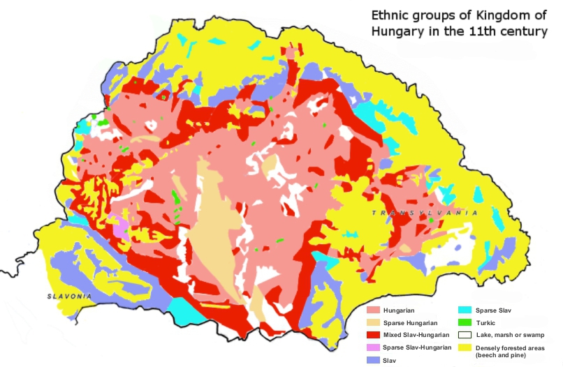
English: Ethnic map of Kingdom of Hungary in the 11th century based on place-names. ..."Although the historical study of place-names is not practised to the same extent in all countries, it is a recognized branch of historiography. It encompasses the etymology of geographical names as well as cultural and chronological variations in the naming of places. To facilitate their study of Hungarian place-names, István Kniezsa and Géza Bárczi developed an analytical framework that blends etymology, typology, and chronology. The validity of this triple approach has been amply demonstrated, thanks not only to the expertise of the two scholars but also to the peculiarity of Hungarian toponymy, which is readily distinguishable from that of any other culture. Most of the early Hungarian toponyms are derived from the names of people, clans, and ethnic groups, or from occupations, and used in the nominative case singular (e.g. Árpád, Megyer, Cseh [Czech], Ács [carpenter]). This type of toponymy appears in the earliest documents, dating from around 1000 AD. The pattern holds well into the 13th century — until the 1220s in western Hungary, and the 1270s in the eastern parts, including Transylvania..."(László Makkai, TRANSYLVANIA IN THE MEDIEVAL HUNGARIAN KINGDOM (896–1526), IN: Köpeczi Béla (General Editor), HISTORY OF TRANSYLVANIA Volume I. From the Beginnings to 1606, Distributed by Columbia University Press, New York, 2001, ISBN 0-88033-479-7)
Magyar: MAGYARORSZÁG NÉPEI A XI. SZÁZADBA http://mek.oszk.hu/09100/09175/html/4.html
A magyar törzsek a X.század végén érkeztek a politikailag akkor még alig szervezett, többnyire gyér, szláv-avar népesség lakta, új hazájába. Honfoglaló őseink a XI.század során akkori félnomád életmódjuknak leginkább megfelelő, korábbi hazájuk természeti környezetére emlékeztető erdős-(főként tölgyes) sztyeppen, stratégiai fekvésű folyóvölgyekben és alacsony dombvidéki területeken települtek le. Az általában a legeltetésre alkalmatlan, gyér aljnövényzetű bükkösök határáig terjedő, korai magyar településterületet többnyire az évi 600 mm-nél kevesebb csapadék és a lösz nagyobb mennyiségű előfordulása jellemezte (Kniezsa I. 1938, Mendöl T. 1947). A X. században a magyarok legnagyobb sűrűségben -- a hadászatilag fontos gyepűkapukon kívül -- a 900 nyarán elfoglalt Dunántúlt, azon belül is az Óbuda-Csepel-Fehérvár-Pécs közötti fejedelmi szállásterület övezetét lakták. Ez főként -- a stratégiai szempontok mellett -- a honfoglalók félnomád életmódjának leginkább megfelelő változatos és eléggé tagolt domborzatnak volt köszönhető (vö. Mendöl T. 1947). Ugyanakkor a honfoglalók etnikai területe az alföldi árterekre, homokvidékekre és a hegy-, dombvidéki zártabb erdőségekre többnyire nem terjedt ki. A nyugati magyar kalandozó csapatok augsburgi vereségét (955), a gyepűvédelmi rendszer megerősítését követően a XI. század végére a magyar etnikai terület kiterjedése a következő volt: északon a Pozsony - Galgóc - Garamszentbenedek - Ipoly-medence - a gömöri Pelsőc - a sáros megyei Eperjes-Sóvár - Tőketerebes - Ungvár - Beregszász vonal; keleten az Erdélyi-medencét (főként a Mezőséget, a Küküllők vidékét és a Maros középső szakaszának környékét) és a Nagy Alföldet kitöltve a hegyvidék lába; délen hozzávetőleg a Mura - Dráva - Duna vonala annyi eltéréssel, hogy a Szerémség északi fele és a Vuka vidéke magyar többségűnek számított; nyugaton Fertő - Sopron - Kőszeg - Pinkamellék vonala (Kniezsa I. 1938, 1939) http://mnynk.unideb.hu/publikaciok/hi_tv_szazadok.pdf |
| Date | |
| Source |
Own work Sources:
|
| Author | Fakirbakir |
Licensing
I, the copyright holder of this work, hereby publish it under the following license:
This file is licensed under the Creative Commons Attribution-Share Alike 3.0 Unported license.
- You are free:
- to share – to copy, distribute and transmit the work
- to remix – to adapt the work
- Under the following conditions:
- attribution – You must give appropriate credit, provide a link to the license, and indicate if changes were made. You may do so in any reasonable manner, but not in any way that suggests the licensor endorses you or your use.
- share alike – If you remix, transform, or build upon the material, you must distribute your contributions under the same or compatible license as the original.
File history
Click on a date/time to view the file as it appeared at that time.
| Date/Time | Thumbnail | Dimensions | User | Comment | |
|---|---|---|---|---|---|
| current | 22:22, 22 January 2013 | | 806 × 526 (236 KB) | Fakirbakir | minor changes (according to Kniezsa's map) |
| 17:15, 21 January 2013 |  | 806 × 526 (235 KB) | Fakirbakir | More understandable, repair, + I remove "Hungarian perspective" because other editors convinced me, science is universal, a scientific statement should not depend on the nationality of the scholar. | |
| 10:35, 21 January 2013 |  | 806 × 526 (232 KB) | Fakirbakir | More neutral / "Hungarian perspective" | |
| 22:08, 19 January 2013 |  | 806 × 526 (226 KB) | Fakirbakir | User created page with UploadWizard |
File usage
The following pages on the English Wikipedia use this file (pages on other projects are not listed):
Global file usage
The following other wikis use this file:
- Usage on eo.wikipedia.org
- Usage on hu.wikipedia.org
- Usage on it.wikipedia.org
- Usage on uk.wikipedia.org