
File:Erie Triangle map 2.jpg
No higher resolution available.
Erie_Triangle_map_2.jpg (664 × 489 pixels, file size: 41 KB, MIME type: image/jpeg)
| This is a file from the Wikimedia Commons. Information from its description page there is shown below. Commons is a freely licensed media file repository. You can help. |
Summary


| Description |
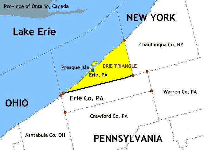
English: Map of Erie Triangle in Erie County, Pennsylvania and surrounding area. Created via National Atlas online mapmaker, a public-domain resource of the U.S. government. |
| Date | |
| Source | |
| Author |
|
Licensing
This file is licensed under the Creative Commons Attribution 2.0 Generic license.
- You are free:
- to share – to copy, distribute and transmit the work
- to remix – to adapt the work
- Under the following conditions:
- attribution – You must give appropriate credit, provide a link to the license, and indicate if changes were made. You may do so in any reasonable manner, but not in any way that suggests the licensor endorses you or your use.
| This file is licensed under the Creative Commons Attribution-Share Alike 3.0 Unported license. Subject to disclaimers. | ||
| ||
| This licensing tag was added to this file as part of the GFDL licensing update. |

|
Permission is granted to copy, distribute and/or modify this document under the terms of the GNU Free Documentation License, Version 1.2 or any later version published by the Free Software Foundation; with no Invariant Sections, no Front-Cover Texts, and no Back-Cover Texts. A copy of the license is included in the section entitled GNU Free Documentation License. Subject to disclaimers. |
Original upload log
The original description page was here. All following user names refer to en.wikipedia.
- 2005-01-10 22:53 Rmhermen 664×489× (41817 bytes)
This image is a derivative work of the following images:
- File:Erie_Triangle_map_1.jpg licensed with Cc-by-2.0, Cc-by-sa-3.0-migrated-with-disclaimers, GFDL-en
- 2011-01-29T15:00:15Z Kelly 664x489 (104239 Bytes) {{BadJPEG}} {{Information |Description={{en|Map of Erie Triangle in Erie County, Pennsylvania and surrounding area. Created via National Atlas online mapmaker, a public-domain resource of the U.S. government.}} |Source=Transf
Uploaded with derivativeFX
File history
Click on a date/time to view the file as it appeared at that time.
| Date/Time | Thumbnail | Dimensions | User | Comment | |
|---|---|---|---|---|---|
| current | 15:05, 29 January 2011 | | 664 × 489 (41 KB) | Kelly | {{BadJPEG}} {{Information |Description={{en|Map of Erie Triangle in Erie County, Pennsylvania and surrounding area. Created via National Atlas online mapmaker, a public-domain resource of the U.S. government.}} |Source=*File:Erie_Triangle_map_1.jpg |
File usage
The following pages on the English Wikipedia use this file (pages on other projects are not listed):
Global file usage
The following other wikis use this file:
- Usage on fa.wikipedia.org
- Usage on fi.wikipedia.org
- Usage on nl.wikipedia.org