
File:Equator and Prime Meridian.svg

Size of this PNG preview of this SVG file: 800 × 406 pixels. Other resolutions: 320 × 162 pixels | 640 × 325 pixels | 1,024 × 520 pixels | 1,280 × 650 pixels | 2,560 × 1,300 pixels | 853 × 433 pixels.
Original file (SVG file, nominally 853 × 433 pixels, file size: 187 KB)
| This is a file from the Wikimedia Commons. Information from its description page there is shown below. Commons is a freely licensed media file repository. You can help. |
Summary
| Description |
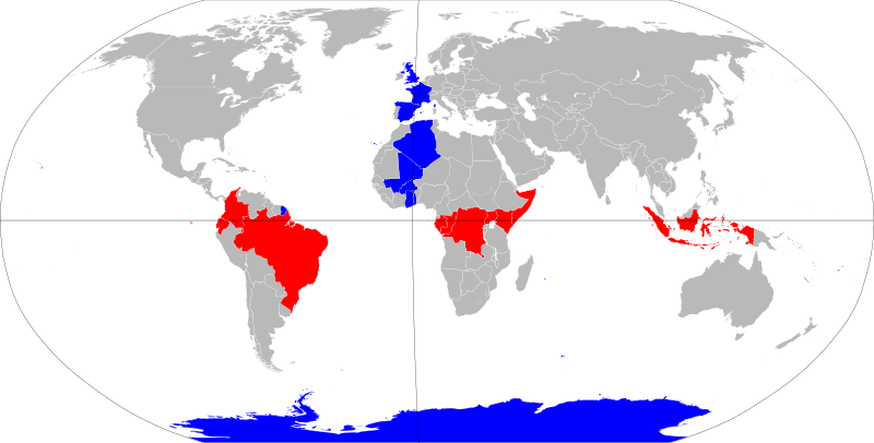
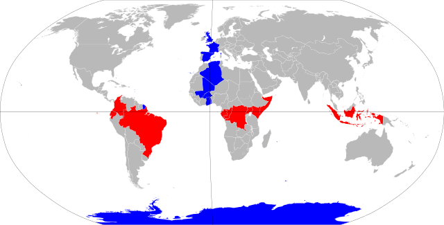
English: The nations of the equator (red) and the prime meridian (blue).
Deutsch: Nationen auf dem Äquator (rot) und dem ersten (Null-)Meridan (blau). |
| Date | |
| Source | BlankMap-World6.svg |
| Author | NuclearVacuum |
| SVG development |
Licensing
I, the copyright holder of this work, hereby publish it under the following licenses:
This file is licensed under the Creative Commons Attribution-Share Alike 3.0 Unported license.
- You are free:
- to share – to copy, distribute and transmit the work
- to remix – to adapt the work
- Under the following conditions:
- attribution – You must give appropriate credit, provide a link to the license, and indicate if changes were made. You may do so in any reasonable manner, but not in any way that suggests the licensor endorses you or your use.
- share alike – If you remix, transform, or build upon the material, you must distribute your contributions under the same or compatible license as the original.

|
Permission is granted to copy, distribute and/or modify this document under the terms of the GNU Free Documentation License, Version 1.2 or any later version published by the Free Software Foundation; with no Invariant Sections, no Front-Cover Texts, and no Back-Cover Texts. A copy of the license is included in the section entitled GNU Free Documentation License. |
You may select the license of your choice.
File history
Click on a date/time to view the file as it appeared at that time.
| Date/Time | Thumbnail | Dimensions | User | Comment | |
|---|---|---|---|---|---|
| current | 09:23, 4 November 2022 | | 853 × 433 (187 KB) | Koopinator | Reverted to version as of 14:51, 29 July 2021 (UTC) My file failed to render. |
| 09:20, 4 November 2022 |  | 2,560 × 1,300 (503 KB) | Koopinator | Antarctica is not a country, but Norway (which claims territory touching the meridian) is. | |
| 14:51, 29 July 2021 |  | 853 × 433 (187 KB) | JoKalliauer | thicker lines, smaller border | |
| 19:15, 18 August 2016 |  | 940 × 477 (1.64 MB) | Certes | Move meridian. Base map is centred on about 15E rather than 0 meridian, so 0 meridian appears curved. Change is most visible near UK. | |
| 01:15, 10 November 2011 |  | 940 × 477 (1.64 MB) | Hoshie | added South Sudan | |
| 23:22, 9 July 2009 |  | 940 × 477 (1.63 MB) | NuclearVacuum | {{Information |Description={{en|1=The nations of the equator and the prime meridian.}} |Source=File:BlankMap-World6.svg<br>{{Inkscape}} |Author=NuclearVacuum |Date=2009-07 |Permission= |other_versions= }} [[Category:User:Nucle |
File usage
The following pages on the English Wikipedia use this file (pages on other projects are not listed):
Global file usage
The following other wikis use this file:
- Usage on an.wikipedia.org
- Usage on azb.wikipedia.org
- Usage on bg.wikipedia.org
- Usage on bn.wikipedia.org
- Usage on ca.wikipedia.org
- Usage on cs.wikipedia.org
- Usage on cy.wikipedia.org
- Usage on en.wikiversity.org
- Usage on es.wikipedia.org
- Usage on fa.wikipedia.org
- Usage on ga.wikipedia.org
- Usage on he.wikipedia.org
- Usage on id.wikipedia.org
- Usage on ilo.wikipedia.org
- Usage on incubator.wikimedia.org
- Usage on ja.wikipedia.org
- Usage on kn.wikipedia.org
- Usage on ko.wikipedia.org
- Usage on kw.wikipedia.org
- Usage on min.wikipedia.org
- Usage on mn.wikipedia.org
- Usage on pl.wikipedia.org
- Usage on ru.wikipedia.org
- Usage on sat.wikipedia.org
- Usage on si.wikipedia.org
- Usage on so.wikipedia.org
- Usage on sr.wikipedia.org
- Usage on su.wikipedia.org
- Usage on te.wikipedia.org
- Usage on tl.wikipedia.org
- Usage on tr.wikipedia.org
- Usage on tt.wikipedia.org
- Usage on yi.wikipedia.org
- Usage on zh.wikipedia.org