
File:Empire colonial français (1920).png

Size of this preview: 800 × 351 pixels. Other resolutions: 320 × 140 pixels | 640 × 281 pixels | 1,425 × 625 pixels.
Original file (1,425 × 625 pixels, file size: 38 KB, MIME type: image/png)
| This is a file from the Wikimedia Commons. Information from its description page there is shown below. Commons is a freely licensed media file repository. You can help. |
.png)

|
This locator map image could be re-created using vector graphics as an SVG file. This has several advantages; see Commons:Media for cleanup for more information. If an SVG form of this image is available, please upload it and afterwards replace this template with
{{vector version available|new image name}}.
It is recommended to name the SVG file “Empire colonial français (1920).svg”—then the template Vector version available (or Vva) does not need the new image name parameter. |
Summary
| Description |
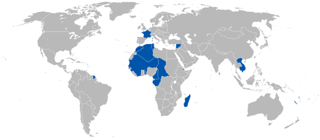
Русский: Французская колониальная империя в 1920 году English: A map of the French Colonial Empire in 1920. |
||
| Date | Uploaded on 27 August 2008, 21:41. | ||
| Source | Own work. | ||
| Author | Vadac. | ||
| Permission (Reusing this file) |
|
||
| Other versions | File:British and French empires 1920.png |
File history
Click on a date/time to view the file as it appeared at that time.
| Date/Time | Thumbnail | Dimensions | User | Comment | |
|---|---|---|---|---|---|
| current | 23:52, 15 July 2023 | | 1,425 × 625 (38 KB) | Randomastwritter | added jubaland |
| 18:51, 7 May 2011 |  | 1,425 × 625 (49 KB) | Quigley | Correct to be more in line with China's internationally recognized borders at the time | |
| 01:52, 13 October 2010 |  | 1,425 × 625 (49 KB) | Vadac | Corrected borders | |
| 10:33, 12 April 2008 |  | 1,357 × 628 (45 KB) | Votolom | {{Information |Description=Map of the French colonial empire at its peak. Territory shown as of 1920, although the empire was roughly the same size from 1905-1960. |Licence={{GFDL-self}} |Date=2008 |Author=User:Votolom }} |
File usage
The following pages on the English Wikipedia use this file (pages on other projects are not listed):
Global file usage
The following other wikis use this file:
- Usage on af.wikipedia.org
- Usage on de.wikipedia.org
- Usage on en.wikivoyage.org
- Usage on eo.wikipedia.org
- Usage on eu.wikipedia.org
- Usage on frr.wikipedia.org
- Usage on hy.wikipedia.org
- Usage on id.wikipedia.org
- Usage on ko.wikipedia.org
- Usage on nl.wikipedia.org
- Usage on pl.wikipedia.org
- Usage on pt.wikipedia.org
- Usage on zh.wikipedia.org
.png)