
File:Ellenabeich - geograph.org.uk - 95384.jpg
No higher resolution available.
Ellenabeich_-_geograph.org.uk_-_95384.jpg (640 × 426 pixels, file size: 115 KB, MIME type: image/jpeg)
| This is a file from the Wikimedia Commons. Information from its description page there is shown below. Commons is a freely licensed media file repository. You can help. |
Summary
| Description |
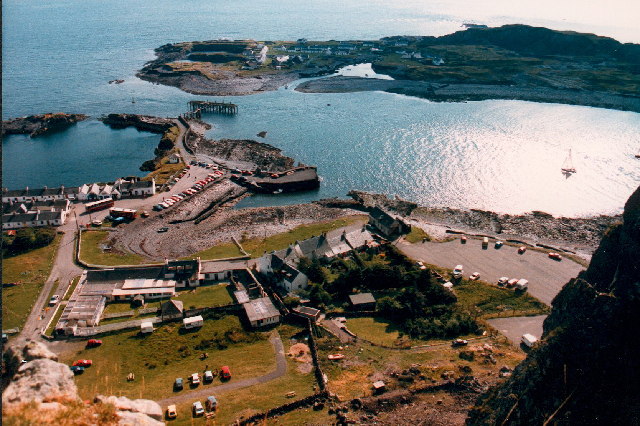
English: Ellenabeich. Looking down from Dun Mor. Shows abandoned slate quarry flooded with sea water to the left of harbour. Ellenabeich and Easdale Island also shown in the picture were famous for slate. This industry no longer exists, as a result there are a number of flooded slate quarries in the vicinity. |
| Date | |
| Source | From geograph.org.uk |
| Author | Kenneth Ross |
| Attribution (required by the license) | Kenneth Ross / Ellenabeich / |
| Object location | | View this and other nearby images on: OpenStreetMap |
|---|
_&language=en)
Licensing

|
This image was taken from the Geograph project collection. See this photograph's page on the Geograph website for the photographer's contact details. The copyright on this image is owned by Kenneth Ross and is licensed for reuse under the Creative Commons Attribution-ShareAlike 2.0 license.
|
This file is licensed under the Creative Commons Attribution-Share Alike 2.0 Generic license.
Attribution: Kenneth Ross
- You are free:
- to share – to copy, distribute and transmit the work
- to remix – to adapt the work
- Under the following conditions:
- attribution – You must give appropriate credit, provide a link to the license, and indicate if changes were made. You may do so in any reasonable manner, but not in any way that suggests the licensor endorses you or your use.
- share alike – If you remix, transform, or build upon the material, you must distribute your contributions under the same or compatible license as the original.
File history
Click on a date/time to view the file as it appeared at that time.
| Date/Time | Thumbnail | Dimensions | User | Comment | |
|---|---|---|---|---|---|
| current | 22:08, 30 January 2010 | | 640 × 426 (115 KB) | GeographBot | == {{int:filedesc}} == {{Information |description={{en|1=Ellenabeich. Looking down from Dun Mor. Shows abandoned slate quarry flooded with sea water to the left of harbour. Ellenabeich and Easdale Island also shown in the picture were famous for slate. T |
File usage
The following pages on the English Wikipedia use this file (pages on other projects are not listed):
Global file usage
The following other wikis use this file:
- Usage on cs.wikipedia.org
- Usage on fr.wikipedia.org
- Usage on it.wikipedia.org
- Usage on sk.wikipedia.org
- Usage on sl.wikipedia.org
- Usage on uk.wikipedia.org