
File:Egypt NK edit.svg

Size of this PNG preview of this SVG file: 512 × 599 pixels. Other resolutions: 205 × 240 pixels | 410 × 480 pixels | 656 × 768 pixels | 875 × 1,024 pixels | 1,749 × 2,048 pixels | 1,282 × 1,501 pixels.
Original file (SVG file, nominally 1,282 × 1,501 pixels, file size: 252 KB)
| This is a file from the Wikimedia Commons. Information from its description page there is shown below. Commons is a freely licensed media file repository. You can help. |
Summary
| Description |
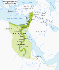
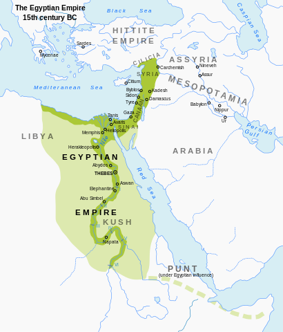
English: Map of Egypt's territorial control during the New Kingdom. Modified from en:Image:Egypt_1450_BC.svg; includes a more muted color scheme. |
| Date | (UTC) |
| Source | Own work based on: Egypt 1450 BC.svg |
| Author | ArdadN, Jeff Dahl |
| Other versions |
[]
|


|
This SVG file contains embedded text that can be translated into your language, using any capable SVG editor, text editor or the SVG Translate tool. For more information see: About translating SVG files. |
Licensing
I, the copyright holder of this work, hereby publish it under the following licenses:
This file is licensed under the Creative Commons Attribution-Share Alike 3.0 Unported license.
- You are free:
- to share – to copy, distribute and transmit the work
- to remix – to adapt the work
- Under the following conditions:
- attribution – You must give appropriate credit, provide a link to the license, and indicate if changes were made. You may do so in any reasonable manner, but not in any way that suggests the licensor endorses you or your use.
- share alike – If you remix, transform, or build upon the material, you must distribute your contributions under the same or compatible license as the original.

|
Permission is granted to copy, distribute and/or modify this document under the terms of the GNU Free Documentation License, Version 1.2 or any later version published by the Free Software Foundation; with no Invariant Sections, no Front-Cover Texts, and no Back-Cover Texts. A copy of the license is included in the section entitled GNU Free Documentation License. |
You may select the license of your choice.
File history
Click on a date/time to view the file as it appeared at that time.
| Date/Time | Thumbnail | Dimensions | User | Comment | |
|---|---|---|---|---|---|
| current | 22:56, 23 September 2023 | | 1,282 × 1,501 (252 KB) | Gaaryeelidmaan | Punt was associated with Myrrh trade, a product found in tip of the Horn https://www.worldhistory.org/punt/ |
| 17:27, 16 October 2013 |  | 1,282 × 1,501 (252 KB) | Rowanwindwhistler | Reverted to version as of 02:05, 7 July 2008, uploaded by mistake. | |
| 17:24, 16 October 2013 |  | 1,282 × 1,501 (251 KB) | Rowanwindwhistler | Some labels corrected, square background added to map title. | |
| 02:05, 7 July 2008 |  | 1,282 × 1,501 (252 KB) | Jeff Dahl | {{Information |Description={{en|1=Map of Egypt's territorial control during the New Kingdom. Modified from Image:Egypt_1450_BC.svg; includes a more muted color scheme.}} |Source=Modified from Image:Egypt_1450_BC.svg by User:Andrei Nacu, modi |
File usage
The following pages on the English Wikipedia use this file (pages on other projects are not listed):
Global file usage
The following other wikis use this file:
- Usage on anp.wikipedia.org
- Usage on ar.wikipedia.org
- Usage on azb.wikipedia.org
- Usage on ba.wikipedia.org
- Usage on be-tarask.wikipedia.org
- Usage on bg.wikipedia.org
- Usage on bxr.wikipedia.org
- Usage on de.wikipedia.org
- Usage on eu.wikipedia.org
- Usage on fa.wikipedia.org
- Usage on gu.wikipedia.org
- Usage on he.wikipedia.org
- Usage on hi.wikipedia.org
- Usage on hy.wikipedia.org
- Usage on id.wikipedia.org
- Usage on incubator.wikimedia.org
- Usage on ja.wikipedia.org
- Usage on ka.wikipedia.org
- Usage on kn.wikipedia.org
- Usage on ko.wikipedia.org
- Usage on mg.wikipedia.org
- Usage on ml.wikipedia.org
- Usage on mt.wikipedia.org
- Usage on pnb.wikipedia.org
- Usage on ru.wikipedia.org
- Usage on sl.wikipedia.org
- Usage on sq.wikipedia.org
- Usage on sv.wikipedia.org
- Usage on sw.wikipedia.org
- Usage on th.wikipedia.org
- Usage on tl.wikipedia.org
- Usage on uk.wikipedia.org
- Usage on ur.wikipedia.org
- Usage on vep.wikipedia.org
- Usage on xmf.wikipedia.org
- Usage on zh.wikipedia.org