
File:Edinburgh Trams Map.png

Size of this preview: 800 × 397 pixels. Other resolutions: 320 × 159 pixels | 640 × 318 pixels | 1,024 × 509 pixels | 1,280 × 636 pixels | 3,504 × 1,741 pixels.
Original file (3,504 × 1,741 pixels, file size: 5.53 MB, MIME type: image/png)
| This is a file from the Wikimedia Commons. Information from its description page there is shown below. Commons is a freely licensed media file repository. You can help. |
Summary
| Description |
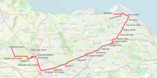
Deutsch: Lagekarte der Edinburgh Trams inklusive Streckenverlàngerung von 2023 |
| Date | |
| Source | Open Street Map Data |
| Creator |
osm-clip by Pechristener |
| Georeferencing | If inappropriate please set warp_status = skip to hide. |
Licensing
I, the copyright holder of this work, hereby publish it under the following license:
This file is licensed under the Creative Commons Attribution 2.0 Generic license.
- You are free:
- to share – to copy, distribute and transmit the work
- to remix – to adapt the work
- Under the following conditions:
- attribution – You must give appropriate credit, provide a link to the license, and indicate if changes were made. You may do so in any reasonable manner, but not in any way that suggests the licensor endorses you or your use.
| This work is licensed under the Open Database License (summary). |
File history
Click on a date/time to view the file as it appeared at that time.
| Date/Time | Thumbnail | Dimensions | User | Comment | |
|---|---|---|---|---|---|
| current | 14:47, 19 June 2023 | | 3,504 × 1,741 (5.53 MB) | Pechristener | labling of stations fixed |
| 20:10, 12 June 2023 |  | 3,504 × 1,741 (5.53 MB) | Pechristener | Route extension | |
| 19:00, 11 May 2020 |  | 2,812 × 1,511 (4.82 MB) | Pechristener | Station West End - Princess Street renamed to West End only. | |
| 13:51, 19 March 2017 |  | 3,000 × 1,612 (3.1 MB) | Pechristener | {{Map |Description={{de|1=Lagekarte der Edinburgh Trams}} |Source=[http://www.openstreetmap.org/ Open Street Map] Data |Date=2016-03-19 |Author=osm-clip by Pechristener |Permission= |other_versions= }} ==... |
File usage
No pages on the English Wikipedia use this file (pages on other projects are not listed).
Global file usage
The following other wikis use this file:
- Usage on de.wikipedia.org
- Usage on he.wikipedia.org
- Usage on it.wikipedia.org
- Usage on pl.wikipedia.org
- Usage on www.wikidata.org
- Usage on zh.wikipedia.org