File:Ebstorfer Weltkarte 2.jpg

Page contents not supported in other languages.
This is a file from the Wikimedia Commons
From Wikipedia, the free encyclopedia

Original file(7,849 × 7,798 pixels, file size: 28.66 MB, MIME type: image/jpeg)

Summary

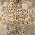
Ebstorf Map  wikidata:Q835613 reasonator:Q835613
Author
Unknown authorUnknown author
image of artwork listed in title parameter on this page
Title
Ebstorf Map
label QS:Les,"Mapamundi de Ebstorf"
label QS:Lfr,"Carte d'Ebstorf"
label QS:Lbe-tarask,"Эбсторфская карта"
label QS:Lde,"Ebstorfer Weltkarte"
label QS:Lpt,"analise do mapa ebstorf"
label QS:Lbe,"Эбсторфская карта"
label QS:Llv,"Ebstorfas karte"
label QS:Lzh,"埃布斯托夫地图"
label QS:Lja,"エブストーフ図"
label QS:Lsv,"Ebstorfska världskartan"
label QS:Lcs,"Ebstorfská mapa"
label QS:Lsk,"Ebstorfská mapa"
label QS:Lpl,"Mapa z Ebstorf"
label QS:Luk,"Ебсторфська карта"
label QS:Lnl,"Mappa Mundi van Ebstorf"
label QS:Lit,"Mappamondo di Ebstorf"
label QS:Lzh-cn,"埃布斯托夫地图"
label QS:Lgl,"Mapamundi de Ebstorf"
label QS:Lca,"Mapamundi d'Ebstorf"
label QS:Len,"Ebstorf Map"
label QS:Lar,"خريطة ابستورف"
label QS:Lel,"Παγκόσμιος χάρτης του Έμπσντορφ"
label QS:Lru,"Эбсторфская карта"
Object type world map / manuscript map / T and O map / Mappa mundi Edit this at Wikidata
Date circa 1235
date QS:P571,+1235-00-00T00:00:00Z/9,P1480,Q5727902
Medium Ziegenpergament
Dimensions height: 350 cm (11.4 ft) Edit this at Wikidata; diameter: 3.5 m (11.7 ft) Edit this at Wikidata
dimensions QS:P2048,+350U174728
dimensions QS:P2386,+3.57U11573
Place of creation
Deutsch: wahrscheinlich im Ebstorfer Kloster (Lüneburger Heide) hergestellt
References https://warnke.web.leuphana.de/hyperimage/EbsKart/index.html#O9999/ Edit this at Wikidata
Authority file
Source/Photographer https://warnke.web.leuphana.de/hyperimage/EbsKart/index.html#O9999/
Other versions http://www2.leuphana.de/ebskart/originals/V1010.jpg

Licensing

This is a faithful photographic reproduction of a two-dimensional, public domain work of art. The work of art itself is in the public domain for the following reason:
Public domain

This work is in the public domain in its country of origin and other countries and areas where the copyright term is the author's life plus 100 years or fewer.


This work is in the public domain in the United States because it was published (or registered with the U.S. Copyright Office) before January 1, 1929.

The official position taken by the Wikimedia Foundation is that "faithful reproductions of two-dimensional public domain works of art are public domain".
This photographic reproduction is therefore also considered to be in the public domain in the United States. In other jurisdictions, re-use of this content may be restricted; see Reuse of PD-Art photographs for details.

Captions

Add a one-line explanation of what this file represents

Items portrayed in this file

depicts

File history

Click on a date/time to view the file as it appeared at that time.

Date/TimeThumbnailDimensionsUserComment
current15:09, 7 April 2019Thumbnail for version as of 15:09, 7 April 20197,849 × 7,798 (28.66 MB)Laserlicht{{Information |description={{de|Ebstorfer Weltkarte, ca. 1300, wahrscheinlich im Ebstorfer Kloster (Lüneburger Heide) hergestellt}} |date=unknown |source=http://www.uni-lueneburg.de/hyperimage/EbsKart/start.html |author= |permission= |other versions= }} {{PD-Art|PD-old-100}} Category:1230s Category:Maps made in the 13th century Category:Medieval diagrams Category:Round maps Category:Ebstorf world map
The following pages on the English Wikipedia use this file (pages on other projects are not listed):

Global file usage

The following other wikis use this file:

Metadata