
File:Eastern New Guinea and New Britain 1944.jpg

Size of this preview: 759 × 599 pixels. Other resolutions: 304 × 240 pixels | 608 × 480 pixels | 972 × 768 pixels | 1,161 × 917 pixels.
Original file (1,161 × 917 pixels, file size: 95 KB, MIME type: image/jpeg)
| This is a file from the Wikimedia Commons. Information from its description page there is shown below. Commons is a freely licensed media file repository. You can help. |
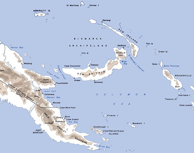
| Description | Map of eastern New Guinea, New Britain, New Island and neighbouring islands with locations of importance in World War II marked |
| Date | (UTC) |
| Source | |
| Author |
F. Temple |
| This is a retouched picture, which means that it has been digitally altered from its original version. Modifications: Cropped. The original can be viewed here: CartwheelAreaMap.jpg:
|
This work is in the public domain in the United States because it is a work prepared by an officer or employee of the United States Government as part of that person’s official duties under the terms of Title 17, Chapter 1, Section 105 of the US Code.
Note: This only applies to original works of the Federal Government and not to the work of any individual U.S. state, territory, commonwealth, county, municipality, or any other subdivision. This template also does not apply to postage stamp designs published by the United States Postal Service since 1978. (See § 313.6(C)(1) of Compendium of U.S. Copyright Office Practices). It also does not apply to certain US coins; see The US Mint Terms of Use.
|
 | |
| This file has been identified as being free of known restrictions under copyright law, including all related and neighboring rights. | ||
Original upload log
This image is a derivative work of the following images:
- File:CartwheelAreaMap.jpg licensed with Cc-pd-mark-footer, PD-USGov
- 2006-12-05T06:19:24Z Cla68 2000x1020 (415447 Bytes) Map of the ''Cartwheel'' area of operations. http://www.ibiblio.org/hyperwar/USA/USA-P-Rabaul/USA-P-Rabaul-3.html
Uploaded with derivativeFX
File history
Click on a date/time to view the file as it appeared at that time.
| Date/Time | Thumbnail | Dimensions | User | Comment | |
|---|---|---|---|---|---|
| current | 10:20, 17 June 2011 | | 1,161 × 917 (95 KB) | Nick-D | {{Information |Description=Map of eastern New Guinea, New Britain, New Island and neighbouring islands with locations of importance in World War II marked |Source=*File:CartwheelAreaMap.jpg |Date=2011-06-17 10:18 (UTC) |Author=United States Army Cen |
File usage
The following pages on the English Wikipedia use this file (pages on other projects are not listed):
Global file usage
The following other wikis use this file:
- Usage on es.wikipedia.org
- Usage on it.wikipedia.org
- Usage on sr.wikipedia.org
- Usage on vi.wikipedia.org