
File:Eastern California from the ISS.jpeg

Size of this preview: 800 × 529 pixels. Other resolutions: 320 × 212 pixels | 640 × 423 pixels | 1,024 × 677 pixels | 1,280 × 846 pixels | 3,029 × 2,002 pixels.
Original file (3,029 × 2,002 pixels, file size: 1.66 MB, MIME type: image/jpeg)
| This is a file from the Wikimedia Commons. Information from its description page there is shown below. Commons is a freely licensed media file repository. You can help. |
Summary
| Description |
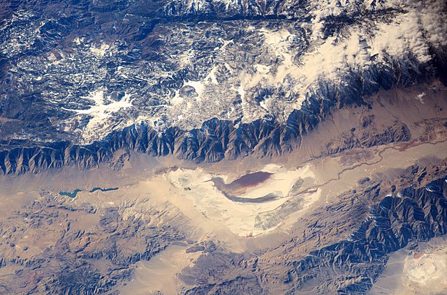
English: Astronauts aboard the International Space Station looked obliquely down at the steep eastern flank of California’s Sierra Nevada. Even from space the topography is impressive—the range drops nearly 11,000 feet from Mt. Whitney (under cloud), the highest mountain in the lower 48 states (14,494 ft), to the floor of Owens Valley (the elevation of the town of Lone Pine is 3,760 ft). The Sierra Nevada landscape is well known for deep, glacially scoured valleys, like Kern Canyon west of Mt. Whitney.
|
| Date | |
| Source | http://eol.jsc.nasa.gov/SearchPhotos/photo.pl?mission=ISS006&roll=E&frame=24783 |
| Author | NASA Earth Observatory |
| Other versions |
|


| Object location | | View this and other nearby images on: OpenStreetMap |
|---|
- Spacecraft altitude: 205 nautical miles (380km)
- I corrected contrast and color cast. —Gorthian (talk)
Licensing
| This file is in the public domain in the United States because it was solely created by NASA. NASA copyright policy states that "NASA material is not protected by copyright unless noted". (See Template:PD-USGov, NASA copyright policy page or JPL Image Use Policy.) | ||
 |
Warnings:
|
File history
Click on a date/time to view the file as it appeared at that time.
| Date/Time | Thumbnail | Dimensions | User | Comment | |
|---|---|---|---|---|---|
| current | 07:04, 17 January 2016 | | 3,029 × 2,002 (1.66 MB) | Gorthian | User created page with UploadWizard |
File usage
The following pages on the English Wikipedia use this file (pages on other projects are not listed):
Global file usage
The following other wikis use this file:
- Usage on ar.wikipedia.org
- Usage on bn.wikipedia.org
- Usage on es.wikipedia.org
- Usage on fr.wikipedia.org
- Usage on it.wikipedia.org
- Usage on zh.wikipedia.org