
File:East Worthing Beach, West Sussex - geograph.org.uk - 1112751.jpg
No higher resolution available.
East_Worthing_Beach,_West_Sussex_-_geograph.org.uk_-_1112751.jpg (640 × 392 pixels, file size: 140 KB, MIME type: image/jpeg)
| This is a file from the Wikimedia Commons. Information from its description page there is shown below. Commons is a freely licensed media file repository. You can help. |
Summary
| Description |
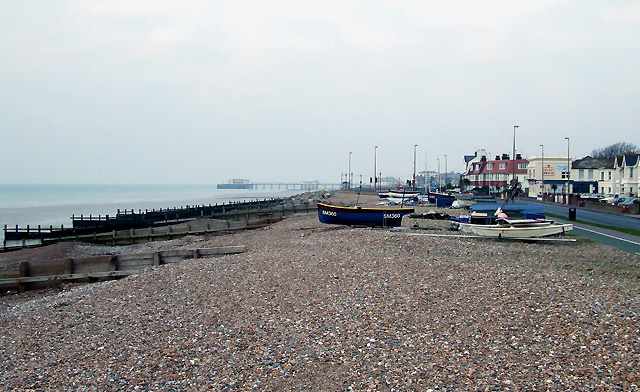
English: East Worthing Beach, West Sussex New Year's Day 2009. High tides do occasionally flood over the top of the shingle bank. Below that, a sandy beach is regularly punctuated by wooden groynes. In some places particularly vulnerable to long-shore drift, large boulders of Norwegian granite have been deposited. In this image, the Half Brick public house (lovely meals!) can be seen in the middle distance, and Worthing Pier is about a mile distant. |
| Date | |
| Source | From geograph.org.uk |
| Author | Roger Kidd |
| Attribution (required by the license) | Roger Kidd / East Worthing Beach, West Sussex / |
| Camera location | | View this and other nearby images on: OpenStreetMap |
|---|
_heading:247.00&language=en)
| Object location | | View this and other nearby images on: OpenStreetMap |
|---|
_heading:247.00&language=en)
Licensing

|
This image was taken from the Geograph project collection. See this photograph's page on the Geograph website for the photographer's contact details. The copyright on this image is owned by Roger Kidd and is licensed for reuse under the Creative Commons Attribution-ShareAlike 2.0 license.
|
This file is licensed under the Creative Commons Attribution-Share Alike 2.0 Generic license.
Attribution: Roger Kidd
- You are free:
- to share – to copy, distribute and transmit the work
- to remix – to adapt the work
- Under the following conditions:
- attribution – You must give appropriate credit, provide a link to the license, and indicate if changes were made. You may do so in any reasonable manner, but not in any way that suggests the licensor endorses you or your use.
- share alike – If you remix, transform, or build upon the material, you must distribute your contributions under the same or compatible license as the original.
File history
Click on a date/time to view the file as it appeared at that time.
| Date/Time | Thumbnail | Dimensions | User | Comment | |
|---|---|---|---|---|---|
| current | 20:57, 24 February 2011 | | 640 × 392 (140 KB) | GeographBot | == {{int:filedesc}} == {{Information |description={{en|1=East Worthing Beach, West Sussex New Year's Day 2009. High tides do occasionally flood over the top of the shingle bank. Below that, a sandy beach is regularly punctuated by wooden groynes. In some |
File usage
The following pages on the English Wikipedia use this file (pages on other projects are not listed):