
File:East Side WW2 Plan.jpg
No higher resolution available.
East_Side_WW2_Plan.jpg (758 × 593 pixels, file size: 173 KB, MIME type: image/jpeg)
| This is a file from the Wikimedia Commons. Information from its description page there is shown below. Commons is a freely licensed media file repository. You can help. |
Summary
| Description |
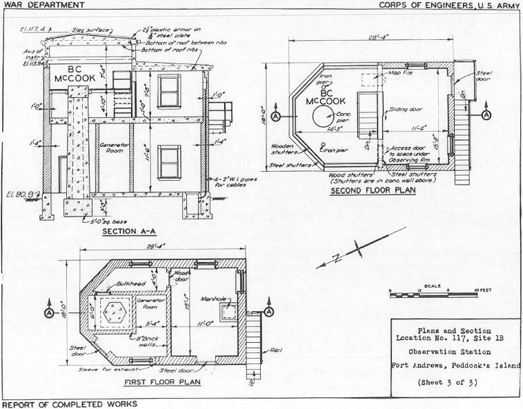
English: This is a plan of the so-called East Side fire control building at Ft. Andrews, completed in 1904. The plan was drawn in about 1944, when the Army was planning to splinterproof the structure. On the second floor, the observing room was in front (to the left) and the room in back was (in 1904) a plotting room.
The elevation A-A clearly shows the huge octagonal concrete pillar that ran from 3 ft. deep under ground up to the second floor observation room. This pillar had a depression position finder mounted on top of it, at an observing height of 113.94 ft. The site itself was 90.9 ft. above mean low water. The plan also shows two less substantial pillars in the observing room, likely for azimuth telescopes used in spotting the fall of fire. In many other fire control towers of this period (such as ones at Ft. Strong (Long Island) and Ft. Warren (Georges Island) in Boston harbor), all that remains (in 2010) of the old structures are the massive concrete pillars for the instruments; the wood, plaster-walled, or brick buildings themselves have long since fallen apart. This is also the case with the collapsed 1907 twin observation station on the westerly hill at Fort Andrews. |
||||||
| Date | circa 1944 | ||||||
| Source | This plan is from the U.S. Engineers' Reports of Completed Works (RCW) for Ft. Andrews. | ||||||
| Author | Unknown author | ||||||
| Permission (Reusing this file) |
|
||||||

Original upload log
Transferred from en.wikipedia to Commons using For the Common Good.
The original description page was here. All following user names refer to en.wikipedia.
| Date/Time | Dimensions | User | Comment |
|---|---|---|---|
| 17:21, 16 May 2010 | 758 × 593 (176,953 bytes) | w:en:Pgrig (talk | contribs) | This is a plan of the so-called East Side fire control building at Ft. Andrews, completed in 1904. The plan was drawn in about 1944, when the Army was planning to splinterproof the structure. On the second floor, the observing room was in front (to the le |
File history
Click on a date/time to view the file as it appeared at that time.
| Date/Time | Thumbnail | Dimensions | User | Comment | |
|---|---|---|---|---|---|
| current | 10:46, 26 March 2020 | | 758 × 593 (173 KB) | Andy Dingley | Transferred from en.wikipedia: see original upload log above |
File usage
The following pages on the English Wikipedia use this file (pages on other projects are not listed):