
File:East African oryx Oryx beisa distribution map 2.png

Size of this preview: 383 × 599 pixels. Other resolutions: 153 × 240 pixels | 568 × 889 pixels.
Original file (568 × 889 pixels, file size: 739 KB, MIME type: image/png)
| This is a file from the Wikimedia Commons. Information from its description page there is shown below. Commons is a freely licensed media file repository. You can help. |
Summary
| Description |
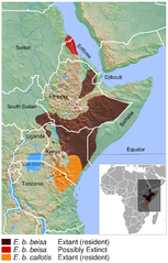
English: Geographical distribution of the East African oryx Oryx beisa. The map was created using the Generic Mapping Tools, GMT, version 5.1.2. |
| Date | |
| Source |
Own work using:
|
| Author | Darekk2 using the IUCN Red List spatial data and GLOBE grids |
Licensing
Attribution: The author of the work and
- the IUCN Red List spatial data.
IUCN (International Union for Conservation of Nature) 2008. Oryx beisa. In: IUCN 2015. The IUCN Red List of Threatened Species. Version 2015.2. http://www.iucnredlist.org. Downloaded on 14 July 2015. - GLOBE grids
(for credits see the Source section)
The NGDC in it's copyright notice says:
As required by 17 U.S.C. 403, third parties producing copyrighted works consisting predominantly of the material produced by U.S. government agencies must provide notice with such work(s) identifying the U.S. Government material incorporated and stating that such material is not subject to copyright protection within the United States. (...).
This file is licensed under the Creative Commons Attribution-Share Alike 4.0 International license.
Attribution: The author of the work
and the IUCN Red List spatial data
and GLOBE
(see above and the Source section)
and the IUCN Red List spatial data
and GLOBE
(see above and the Source section)
- You are free:
- to share – to copy, distribute and transmit the work
- to remix – to adapt the work
- Under the following conditions:
- attribution – You must give appropriate credit, provide a link to the license, and indicate if changes were made. You may do so in any reasonable manner, but not in any way that suggests the licensor endorses you or your use.
- share alike – If you remix, transform, or build upon the material, you must distribute your contributions under the same or compatible license as the original.
File history
Click on a date/time to view the file as it appeared at that time.
| Date/Time | Thumbnail | Dimensions | User | Comment | |
|---|---|---|---|---|---|
| current | 23:18, 19 June 2016 | | 568 × 889 (739 KB) | Darekk2 | added border between Sudans |
| 17:07, 15 July 2015 |  | 568 × 889 (738 KB) | Darekk2 | thinner borders in the inset map | |
| 16:51, 15 July 2015 |  | 568 × 889 (739 KB) | Darekk2 | thinner borders in the inset map | |
| 15:11, 15 July 2015 |  | 568 × 889 (739 KB) | Darekk2 | latin names to oblique (italics) | |
| 14:44, 15 July 2015 |  | 568 × 889 (738 KB) | Darekk2 | User created page with UploadWizard |
File usage
The following pages on the English Wikipedia use this file (pages on other projects are not listed):
Global file usage
The following other wikis use this file:
- Usage on es.wikipedia.org
- Usage on hu.wikipedia.org
- Usage on it.wikipedia.org
- Usage on ka.wikipedia.org
- Usage on ko.wikipedia.org
- Usage on nl.wikipedia.org
- Usage on pl.wikipedia.org
- Usage on ru.wikipedia.org
- Usage on sco.wikipedia.org
- Usage on sr.wikipedia.org
- Usage on vi.wikipedia.org