
File:EF4damageinNewnanGA-2021.jpg

Size of this preview: 450 × 600 pixels. Other resolutions: 180 × 240 pixels | 360 × 480 pixels | 576 × 768 pixels | 768 × 1,024 pixels | 1,536 × 2,048 pixels | 3,024 × 4,032 pixels.
Original file (3,024 × 4,032 pixels, file size: 1.91 MB, MIME type: image/jpeg)
| This is a file from the Wikimedia Commons. Information from its description page there is shown below. Commons is a freely licensed media file repository. You can help. |
Summary
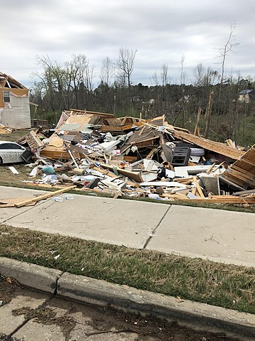
| Description | A home, along Fairview Drive in Newnan, Georgia, completely leveled by a violent EF4 tornado on March 25–26, 2021. The National Weather Service rated the damage at this location EF4 on the Enhanced Fujita scale with winds estimated at 170 miles per hour (270 km/h). The National Weather Service damage survey team also said the following about this location: “Possible EF4 point. 2 houses both totally destroyed in this section.” |
| Date | |
| Source | NOAA’s Damage Assessment Toolkit: https://apps.dat.noaa.gov/StormDamage/DamageViewer/ (Exact URL) |
| Author | NWS Peach Tree City |
| Permission (Reusing this file) |
National Weather Service |
| Camera location | | View this and other nearby images on: OpenStreetMap |
|---|
Licensing
This image is in the public domain because it was stored on the web servers of the U.S. National Weather Service. NWS-created images are automatically public domain in the U.S. since the NWS is a part of the U.S. government. However, the NWS sites also host non-NWS images which have been submitted by individuals: these are generally shown as "Courtesy of ...". Such images have explicitly been released to the public domain by the copyright owner as part of the upload process.
As stated at https://www.weather.gov/fsd/disclaimer: "By submitting images, you understand that your image is being released into the public domain. This means that your photo or video may be downloaded, copied, and used by others." Thus, all* images on NWS servers are public domain (including "Courtesy of ..." and “Photo by ...” images) unless specifically stated otherwise through a copyright (©) watermark.
*A deletion discussion in November 2023 ruled that Getty Images on the web servers of NWS, are to be considered copyrighted, even without a copyright (©) watermark and are the sole exception to this rule.
|
File history
Click on a date/time to view the file as it appeared at that time.
| Date/Time | Thumbnail | Dimensions | User | Comment | |
|---|---|---|---|---|---|
| current | 05:19, 4 April 2021 | | 3,024 × 4,032 (1.91 MB) | TornadoInformation12 | {{Information |Description=Low-end EF4 damage to a house that was completely leveled in Newnan, Georgia. |Source=https://apps.dat.noaa.gov/StormDamage/DamageViewer/ |Date=April 4, 2021 |Author=NWS Peach Tree City |Permission=National Weather Service |other_versions= }} |
File usage
The following pages on the English Wikipedia use this file (pages on other projects are not listed):