
File:Dry line satellite description.png
No higher resolution available.
Dry_line_satellite_description.png (350 × 330 pixels, file size: 89 KB, MIME type: image/png)
| This is a file from the Wikimedia Commons. Information from its description page there is shown below. Commons is a freely licensed media file repository. You can help. |
Summary
| Description |
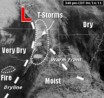
English: In the picture: The satellite showed thunderstorms popping up quickly along a dryline to the west of Arkansas at 340 pm CDT on April 14, 2011. The dash dry line separate very dry and moist airmass. |
| Date | |
| Source | http://www.srh.noaa.gov/lzk/?n=svr0411byr.htm |
| Author | National Weather Service Weather Forecast Office of Little Rock, AR |
| Other versions | Derivative works of this file: Dry line satellite description fr.svg |
Licensing
This image is in the public domain because it contains materials that originally came from the U.S. National Oceanic and Atmospheric Administration, taken or made as part of an employee's official duties.
|
File history
Click on a date/time to view the file as it appeared at that time.
| Date/Time | Thumbnail | Dimensions | User | Comment | |
|---|---|---|---|---|---|
| current | 11:30, 27 June 2016 | | 350 × 330 (89 KB) | Pierre cb | User created page with UploadWizard |
File usage
The following pages on the English Wikipedia use this file (pages on other projects are not listed):
Global file usage
The following other wikis use this file:
- Usage on fi.wikipedia.org
- Usage on lmo.wikipedia.org