
File:Drinking Fountain, Llanboidy - geograph.org.uk - 602813.jpg

Size of this preview: 426 × 599 pixels. Other resolutions: 170 × 240 pixels | 455 × 640 pixels.
Original file (455 × 640 pixels, file size: 95 KB, MIME type: image/jpeg)
| This is a file from the Wikimedia Commons. Information from its description page there is shown below. Commons is a freely licensed media file repository. You can help. |
Summary
| Description |
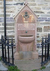
English: Drinking Fountain, Llanboidy Outside the village hall, and inscribed This fountain is erected to commemorate the completion of the work for supplying this village with water in compliance with the last wish of W. R. H. Powell M.P.. The village hall was built in 1881 as a market hall, and the water supply and sewerage system was installed in 1890, the first piped water in Carmarthenshire. |
| Date | |
| Source | From geograph.org.uk |
| Author | Humphrey Bolton |
| Attribution (required by the license) | Humphrey Bolton / Drinking Fountain, Llanboidy / |
| Camera location | | View this and other nearby images on: OpenStreetMap |
|---|
_heading:225.00&language=en)
| Object location | | View this and other nearby images on: OpenStreetMap |
|---|
_heading:225.00&language=en)
Licensing

|
This image was taken from the Geograph project collection. See this photograph's page on the Geograph website for the photographer's contact details. The copyright on this image is owned by Humphrey Bolton and is licensed for reuse under the Creative Commons Attribution-ShareAlike 2.0 license.
|
This file is licensed under the Creative Commons Attribution-Share Alike 2.0 Generic license.
Attribution: Humphrey Bolton
- You are free:
- to share – to copy, distribute and transmit the work
- to remix – to adapt the work
- Under the following conditions:
- attribution – You must give appropriate credit, provide a link to the license, and indicate if changes were made. You may do so in any reasonable manner, but not in any way that suggests the licensor endorses you or your use.
- share alike – If you remix, transform, or build upon the material, you must distribute your contributions under the same or compatible license as the original.
File history
Click on a date/time to view the file as it appeared at that time.
| Date/Time | Thumbnail | Dimensions | User | Comment | |
|---|---|---|---|---|---|
| current | 22:57, 6 February 2011 | | 455 × 640 (95 KB) | GeographBot | == {{int:filedesc}} == {{Information |description={{en|1=Drinking Fountain, Llanboidy Outside the village hall, and inscribed This fountain is erected to commemorate the completion of the work for supplying this village with water in compliance with the |
File usage
The following pages on the English Wikipedia use this file (pages on other projects are not listed):
Global file usage
The following other wikis use this file:
- Usage on cy.wikipedia.org