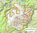
File:Dreiborner Hochfläche.png

Page contents not supported in other languages.
This is a file from the Wikimedia Commons
From Wikipedia, the free encyclopedia

Original file(814 × 735 pixels, file size: 1.18 MB, MIME type: image/png)

Summary

Description
Deutsch: Geografische Darstellung der Dreiborner Hochfläche gem. Literatur. Autor=Ewald Gläßer, Herausgeber=Bundesforschungsanstalt für Landeskunde und Raumordnung,Titel:Die naturräumlichen Einheiten auf Blatt 122/123 Köln Aachen, Sammelwerk Geographische Landesaufnahme 1:200000 Naturräumliche Gliederung Deutschland, Selbstverlag, Bad Godesberg 1978 Karte Geographische Landesaufnahme, naturräumliche Gliederung, siehe hier Teil 282 bzw. 282.5
Date
Source © OpenTopoMap, http://geographie.giersbeck.de/karten/123.pdf
Author OpenStreetMap-Mitwirkende, SRTM, Albert Gr gem. Vorlage Bundesforschungsanstalt für Landeskunde und Raumordnung

Licensing

w:en:Creative Commons
attribution share alike
This file is licensed under the Creative Commons Attribution-Share Alike 3.0 Unported license.
Attribution: OpenStreetMap contributors
You are free:
  • to share – to copy, distribute and transmit the work
  • to remix – to adapt the work
Under the following conditions:
  • attribution – You must give appropriate credit, provide a link to the license, and indicate if changes were made. You may do so in any reasonable manner, but not in any way that suggests the licensor endorses you or your use.
  • share alike – If you remix, transform, or build upon the material, you must distribute your contributions under the same or compatible license as the original.

Captions

Add a one-line explanation of what this file represents

Items portrayed in this file

depicts

20 February 2016

image/png

File history

Click on a date/time to view the file as it appeared at that time.

Date/TimeThumbnailDimensionsUserComment
current08:14, 10 April 2021Thumbnail for version as of 08:14, 10 April 2021814 × 735 (1.18 MB)Albert Gr.Reverted to version as of 08:11, 10 April 2021 (UTC)
08:12, 10 April 2021Thumbnail for version as of 08:12, 10 April 2021814 × 735 (1.49 MB)Albert Gr.Reverted to version as of 08:04, 10 April 2021 (UTC)
08:11, 10 April 2021Thumbnail for version as of 08:11, 10 April 2021814 × 735 (1.18 MB)Albert Gr.Lage der höchsten Erhebung
08:04, 10 April 2021Thumbnail for version as of 08:04, 10 April 2021814 × 735 (1.49 MB)Albert Gr.Lage der höchsten Erhebung
12:09, 20 February 2016Thumbnail for version as of 12:09, 20 February 2016814 × 735 (1.22 MB)Albert Gr.User created page with UploadWizard
The following pages on the English Wikipedia use this file (pages on other projects are not listed):

Global file usage

The following other wikis use this file:

Metadata