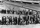
File:Dorothea Lange - American internees in mess hall line at Tanforan Assembly Center San Bruno CA April 29 1942.gif

Page contents not supported in other languages.
This is a file from the Wikimedia Commons
From Wikipedia, the free encyclopedia

Summary

Description
English: San Bruno, California. This assembly center has been open for two days. Bus-load after bus-load of evacuated persons of Japanese ancestry are arriving on this day after going through the necessary procedures, they are guided to the quarters assigned to them in the barracks. Only one mess hall was operating today. Photograph shows line-up of newly arrived evacuees outside this mess hall at noon. Note barracks in background, just built, for family units. There are three types of quarters in the center of post office. The wide road which runs diagonally across the photograph is the former racetrack.
Date Taken on 29 April 1942
Source
This media is available in the holdings of the National Archives and Records Administration, cataloged under the National Archives Identifier (NAID) 537677.

This tag does not indicate the copyright status of the attached work. A normal copyright tag is still required. See Commons:Licensing.

العربية  Deutsch  English  español  français  italiano  日本語  한국어  македонски  മലയാളം  Nederlands  polski  português  русский  slovenščina  Türkçe  українська  Tiếng Việt  中文(简体)  中文(繁體)  +/−

Author
Dorothea Lange  (1895–1965)  wikidata:Q230673 q:en:Dorothea Lange
 
Dorothea Lange
Alternative names
Birth name: Dorothea Margaretta Nutzhorn; Dorothea Nutzhorn; Dorothea Lange Taylor; Dorothea Margaretta Nutzhorn Dixon Taylor Lange; Dorothea Lange
Description American-German journalist, photojournalist, photographer, documentarian and artist
Date of birth/death 26 May 1895 Edit this at Wikidata 11 October 1965 Edit this at Wikidata
Location of birth/death Hoboken San Francisco
Work location
Authority file
creator QS:P170,Q230673
Other versions
File:Japanese American Internment Center.jpg
A JPG version with different cropping and contrast
Camera location37° 38′ 09.6″ N, 122° 25′ 04.8″ W Kartographer map based on OpenStreetMap.View this and other nearby images on: OpenStreetMapinfo

Licensing

This file is a work of an employee of the Executive Office of the President of the United States, taken or made as part of that person's official duties. As a work of the U.S. federal government, it is in the public domain.

italiano  sicilianu  Deutsch  español  português  English  français  Nederlands  galego  slovenščina  Tiếng Việt  македонски  русский  മലയാളം  ไทย  한국어  日本語  中文(简体)‎  中文(繁體)‎  עברית  العربية  فارسی  +/−

Captions

Add a one-line explanation of what this file represents

Items portrayed in this file

depicts

29 April 1942

37°38'10"N, 122°25'5"W

File history

Click on a date/time to view the file as it appeared at that time.

Date/TimeThumbnailDimensionsUserComment
current23:33, 28 July 2016Thumbnail for version as of 23:33, 28 July 2016600 × 445 (106 KB)Rupert ClaytonUser created page with UploadWizard
The following pages on the English Wikipedia use this file (pages on other projects are not listed):