
File:Deutschland Besatzungszonen - 1945 1946.svg

Original file (SVG file, nominally 650 × 830 pixels, file size: 225 KB)
| This is a file from the Wikimedia Commons. Information from its description page there is shown below. Commons is a freely licensed media file repository. You can help. |
 AS THIS MAP HAS WRONG BORDERS, PLEASE USE UPDATED MAP: File:Deutschland Besatzungszonen 8 Jun 1947 - 22 Apr 1949.svg
| Description |
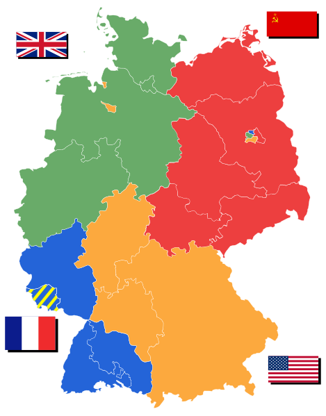
English: Allied occupation zones in Germany after 02/21/1947 after Lippe became part of Northrhine-Westphalia
Deutsch: Alliierte Besatzungszonen Deutschlands nachdem Lippe zu NRW am 21. Januar 1947 beigetreten ist.
mit Länder
Nederlands: Geallieerde bezettingszones in Duitsland na 22.01.1947 met deelstaten
Polski: Alianckie strefy okupacyjne w Niemczech po 02/21/1947 |
|||||||||||
| Date | 16 April | |||||||||||
| Source | Own work based on: File:Deutschland Besatzungszonen 1945 1946.png and File:Karte Deutsche Bundesländer (nummeriert).svg | |||||||||||
| Author | 52 Pickup | |||||||||||
| Permission (Reusing this file) |
This file is licensed under the Creative Commons Attribution-Share Alike 2.5 Generic license.
|
|||||||||||
| SVG development |

.svg)
File history
Click on a date/time to view the file as it appeared at that time.
| Date/Time | Thumbnail | Dimensions | User | Comment | |
|---|---|---|---|---|---|
| current | 19:37, 22 July 2008 | | 650 × 830 (225 KB) | 52 Pickup | Corrected assignment of Lindau |
| 11:39, 7 May 2007 |  | 650 × 830 (225 KB) | 52 Pickup | with corrected borders for eastern states | |
| 18:27, 16 April 2007 |  | 650 × 830 (224 KB) | 52 Pickup | damn, uploaded the wrong file first time | |
| 18:21, 16 April 2007 |  | 744 × 1,052 (1.13 MB) | 52 Pickup | {{Information |Description= {{en|Allied occupation zones in Germany 1945/1946 with states}} {{de|Allierte Besatzungszonen Deutschlands 1945/1946 mit Länder}} {{nl|Geallieerde bezettingszones in Duitsland 1945/1946 met deelstaten}} |Source= Based on [[Ima |
File usage
Global file usage
The following other wikis use this file:
- Usage on als.wikipedia.org
- Usage on ar.wikipedia.org
- Usage on arz.wikipedia.org
- Usage on azb.wikipedia.org
- Usage on az.wikipedia.org
- Usage on be.wikipedia.org
- Usage on bn.wikipedia.org
- Usage on cs.wikipedia.org
- Usage on da.wikipedia.org
- Usage on de.wikipedia.org
- Usage on es.wikipedia.org
- Usage on et.wikipedia.org
- Usage on eu.wikipedia.org
- Usage on fo.wikipedia.org
- Usage on fr.wikipedia.org
- Forces françaises en Allemagne
- Gestion des clubs sportifs en RDA
- Amateurliga Saarland
- Football en RDA
- Championnat de RDA de football de troisième division
- Ligue supérieure de football d'Allemagne du Sud 1945-1946
- Ligue supérieure de football d'Allemagne du Sud-Ouest 1945-1946
- Ligue supérieure de football d'Allemagne du Sud 1946-1947
- Chronologie de l'Allemagne
- Usage on he.wikipedia.org
- Usage on hu.wikipedia.org
- Usage on id.wikipedia.org
- Usage on it.wikiversity.org
- Usage on ja.wikipedia.org
- Usage on kn.wikipedia.org
- Usage on lt.wikipedia.org
- Usage on nl.wikipedia.org
- Usage on oc.wikipedia.org
View more global usage of this file.