
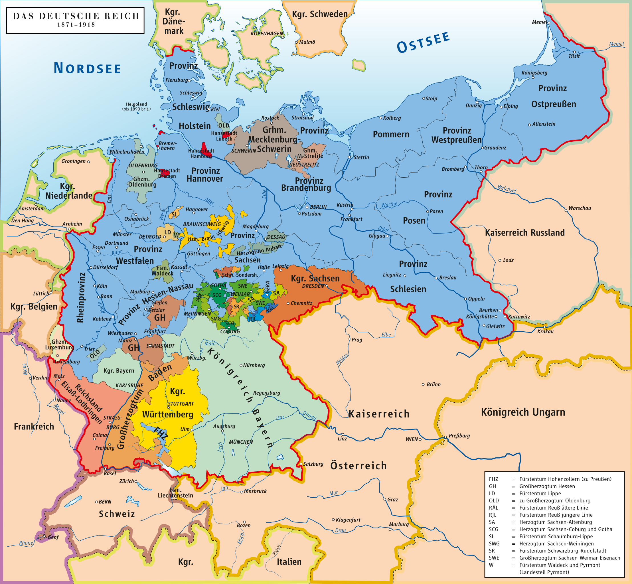
File:Deutsches Reich (1871-1918)-de.svg

Size of this PNG preview of this SVG file: 649 × 600 pixels. Other resolutions: 260 × 240 pixels | 519 × 480 pixels | 831 × 768 pixels | 1,108 × 1,024 pixels | 2,216 × 2,048 pixels | 992 × 917 pixels.
Original file (SVG file, nominally 992 × 917 pixels, file size: 1.48 MB)
| This is a file from the Wikimedia Commons. Information from its description page there is shown below. Commons is a freely licensed media file repository. You can help. |
Summary
| Description |
Deutsch: Karte des Deutschen Reiches 1871–1918 English: Map of German Reich 1871–1918 |
| Date | |
| Source |
Own work using::
|
| Author | ziegelbrenner |
| Permission (Reusing this file) |
GNU FDL |
| Other versions |
Derivative works of this file: Wahlrecht Deutsches Reich 1914.svg
[]
|

-de.svg)
-en.png)
-es.svg)
-eo.svg)
-fa.svg)
-fr.svg)
-ms.svg)
-oc.png)
-ar.svg)
-he.svg)
-tr.svg)
-de.svg)
Licensing
I, the copyright holder of this work, hereby publish it under the following licenses:

|
Permission is granted to copy, distribute and/or modify this document under the terms of the GNU Free Documentation License, Version 1.2 or any later version published by the Free Software Foundation; with no Invariant Sections, no Front-Cover Texts, and no Back-Cover Texts. A copy of the license is included in the section entitled GNU Free Documentation License. |
| This file is licensed under the Creative Commons Attribution-Share Alike 3.0 Unported license. | ||
| ||
| This licensing tag was added to this file as part of the GFDL licensing update. |
This file is licensed under the Creative Commons Attribution-Share Alike 2.5 Generic, 2.0 Generic and 1.0 Generic license.
- You are free:
- to share – to copy, distribute and transmit the work
- to remix – to adapt the work
- Under the following conditions:
- attribution – You must give appropriate credit, provide a link to the license, and indicate if changes were made. You may do so in any reasonable manner, but not in any way that suggests the licensor endorses you or your use.
- share alike – If you remix, transform, or build upon the material, you must distribute your contributions under the same or compatible license as the original.
You may select the license of your choice.
File history
Click on a date/time to view the file as it appeared at that time.
-de.svg&dir=prev)
-de.svg&offset=20080121093639)
-de.svg&offset=&limit=20)
-de.svg&offset=&limit=50)
-de.svg&offset=&limit=100)
-de.svg&offset=&limit=250)
-de.svg&offset=&limit=500)
| Date/Time | Thumbnail | Dimensions | User | Comment | |
|---|---|---|---|---|---|
| current | 11:45, 13 December 2020 | | 992 × 917 (1.48 MB) | Intforce | Reduce file size |
| 12:19, 22 June 2016 |  | 992 × 917 (2.03 MB) | Ziegelbrenner | Kleine Korrekturen | |
| 11:26, 12 July 2015 |  | 777 × 717 (1.31 MB) | .gs8 | Attribute sodipodi:nodetypes="..." deleted | |
| 12:29, 6 July 2015 |  | 777 × 717 (1.31 MB) | Ziegelbrenner | 2015-07-06 some corrections | |
| 10:48, 2 March 2015 |  | 992 × 917 (1.98 MB) | Ziegelbrenner | 2015-03-02 | |
| 22:17, 25 September 2013 |  | 971 × 896 (2.05 MB) | Ras67 | cropped | |
| 12:17, 9 January 2013 |  | 992 × 917 (1.97 MB) | Ziegelbrenner | 2013-01-09 | |
| 23:01, 10 April 2008 |  | 778 × 783 (911 KB) | JanSöderback~commonswiki | Fix SVG namespace bug. {{self2|GFDL|cc-by-sa-2.5,2.0,1.0}} This is a trivial fix of kgberger's work. | |
| 22:55, 10 April 2008 |  | 778 × 783 (911 KB) | JanSöderback~commonswiki | == Beschreibung == {{Information |Description=Karte des Deutschen Reiches 1871–1918 / Map of German Reich 1871–1918 |Source=own drawing/Source of Information: Putzger – Historischer Weltatlas, 89. Auflage, 1965 |Date=2008-01-14 |Author=[[:de:Benutze | |
| 09:36, 21 January 2008 |  | 778 × 783 (911 KB) | Ziegelbrenner |
File usage
The following pages on the English Wikipedia use this file (pages on other projects are not listed):
- History of Germany
- List of towns and cities in Germany by historical population
- Reichsbürger movement
- Talk:World War II/Archive 48
- Talk:World War II/Archive 52
- User:Basler04/GE
- User:Foobaa
- User:Michael!/Deutschland
- User:SucreRouge/sandbox
- User talk:Tresckow
- Wikipedia:Village pump (technical)/Archive 144
Global file usage
The following other wikis use this file:
- Usage on af.wikipedia.org
- Usage on als.wikipedia.org
- Usage on ang.wikipedia.org
- Usage on an.wikipedia.org
- Usage on ar.wikipedia.org
- Usage on azb.wikipedia.org
- Usage on az.wikipedia.org
- Usage on ba.wikipedia.org
- Usage on be.wikipedia.org
- Usage on bg.wikipedia.org
- Usage on br.wikipedia.org
- Usage on bs.wikipedia.org
- Usage on cs.wikipedia.org
- Dějiny Německa
- Německá říše
- Německé císařství
- Bavorské království
- Pruské království
- Dějiny Pruska
- Sasko-výmarsko-eisenašské vévodství
- Bádenské velkovévodství
- Hesenské velkovévodství
- Württemberské království
- Saské království
- Šablona:Spolkové země Německého císařství
- Seznam německých panovníků podle data abdikace v roce 1918
- Sasko-kobursko-gothajské vévodství
- Meklenbursko-střelické velkovévodství
- Říšští občané
- Usage on da.wikipedia.org
View more global usage of this file.
-de.svg)
-de.svg)