
File:Democratic presidential primary results by county, 2012.svg

Size of this PNG preview of this SVG file: 800 × 508 pixels. Other resolutions: 320 × 203 pixels | 640 × 406 pixels | 1,024 × 650 pixels | 1,280 × 813 pixels | 2,560 × 1,626 pixels | 1,304 × 828 pixels.
Original file (SVG file, nominally 1,304 × 828 pixels, file size: 1.54 MB)
| This is a file from the Wikimedia Commons. Information from its description page there is shown below. Commons is a freely licensed media file repository. You can help. |
Summary
| Description |
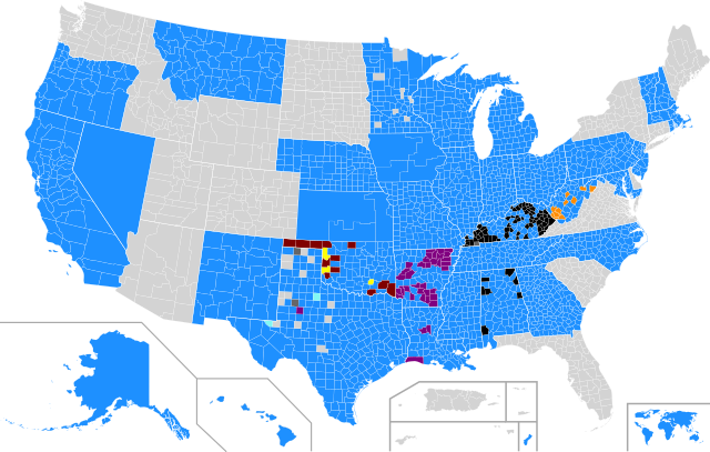
English: Democratic presidential primary, 2012 results by county (exceptions: Iowa & Kansas – congressional districts, Louisiana – parishes, Alaska, Democrats Abroad, Guam, Hawaii, Nevada & Washington, D.C. – at-large)
Barack Obama
John Wolfe Jr.
Keith Russell Judd
Bob Ely
Randall Terry
Jim Rogers
Uncommitted
Tie
No votes/information available |
| Date | |
| Source | Shapes derived from Republican Party presidential primaries results by county, 2016 and Democratic Party presidential primaries results, 2016 by margin of victory, slightly modified and colored in by Mr.Election |
| Author | Mr.Election |
Licensing
I, the copyright holder of this work, hereby publish it under the following license:
This file is licensed under the Creative Commons Attribution-Share Alike 4.0 International license.
- You are free:
- to share – to copy, distribute and transmit the work
- to remix – to adapt the work
- Under the following conditions:
- attribution – You must give appropriate credit, provide a link to the license, and indicate if changes were made. You may do so in any reasonable manner, but not in any way that suggests the licensor endorses you or your use.
- share alike – If you remix, transform, or build upon the material, you must distribute your contributions under the same or compatible license as the original.
File history
Click on a date/time to view the file as it appeared at that time.
| Date/Time | Thumbnail | Dimensions | User | Comment | |
|---|---|---|---|---|---|
| current | 19:46, 7 March 2017 | | 1,304 × 828 (1.54 MB) | WikiBunny2K1 | Removed SC |
| 19:57, 18 February 2017 |  | 1,304 × 828 (1.54 MB) | WikiBunny2K1 | Updated shapes | |
| 17:57, 18 February 2017 |  | 1,304 × 828 (1.46 MB) | WikiBunny2K1 | Updated the shape of the box for the territories | |
| 04:31, 18 February 2017 |  | 1,304 × 828 (1.46 MB) | WikiBunny2K1 | Added Hawaii at-large and removed Northern Mariana Islands | |
| 03:55, 15 February 2017 |  | 1,304 × 827 (1.57 MB) | WikiBunny2K1 | Moved Alaska slightly to the right and updated the shape of Guam | |
| 05:14, 5 February 2017 |  | 1,304 × 827 (1.57 MB) | WikiBunny2K1 | Added Alaska and Nevada as at-large | |
| 21:27, 16 January 2017 |  | 1,304 × 827 (1.58 MB) | WikiBunny2K1 | Updated a parish in Louisiana | |
| 01:19, 16 January 2017 |  | 1,304 × 827 (1.58 MB) | WikiBunny2K1 | Added Nebraska | |
| 22:46, 15 January 2017 |  | 1,304 × 827 (1.58 MB) | WikiBunny2K1 | Thinner outline for CD maps | |
| 22:13, 15 January 2017 |  | 1,304 × 827 (1.58 MB) | WikiBunny2K1 | Added territories and updated map shape |
File usage
The following pages on the English Wikipedia use this file (pages on other projects are not listed):
Global file usage
The following other wikis use this file:
- Usage on es.wikipedia.org
- Usage on ko.wikipedia.org
- Usage on pl.wikipedia.org